Every Place Has a Story

Michael Kluckner’s Toshiko: a graphic novel

the_title()

If you are like me and have a couple of Michael Kluckner’s books at home, you might be surprised to learn that his latest effort is a graphic novel.

In his latest book, Toshiko, Michael has replaced his paint brush with a pencil, and he’s taken a leap into fiction.

Tosh cover

Turns out, Michael kicked off his career as a cartoonist back in the ‘70s, and in many ways, this is a return to his roots.

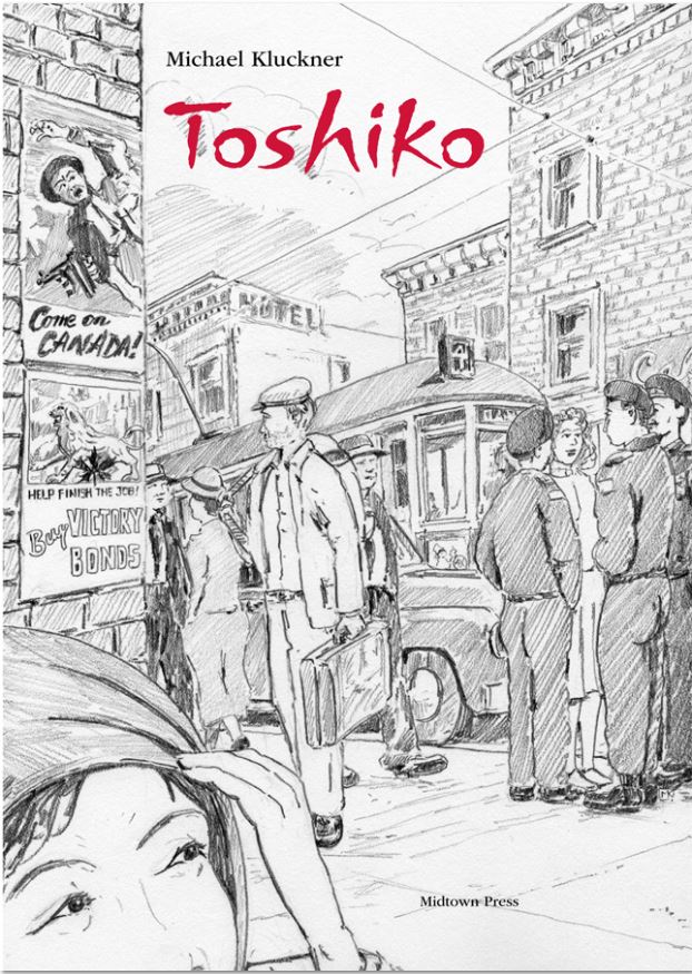
As expected, Toshiko is steeped in historical detail. Michael says inspiration for the graphic novel came from his 2011 book Vanishing British Columbia. In that book, he describes a farm near Shuswap Lake run by Henry and Hilda Calhoun, who when the Japanese were declared enemy aliens during the war years, the couple welcomed a group of Japanese-Canadian families onto their property.

Tosh 1

Toshiko is the name of the protagonist, a Japanese Canadian teen sent with her family to the Shuswap to work on a farm during the Second World War. In Michael’s story, Toshiko falls for a local boy called Cowboy, and in a Romeo-Juliet type scenario, his father kicks him out, and the kids take off for Vancouver.

Tosh 2
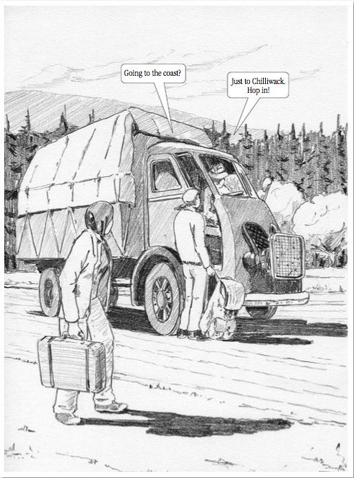
“I thought I’d have a romance develop and see how that played out as a way of describing all of the social class issues and the race issues and the war time issues,” he says. “I didn’t really know what was going to happen when I started, but I knew they were going to go to Vancouver and that would give me the opportunity to get some Vancouver stuff in and create that whole world around the Chinatown hotel and the squatter’s camp at False Creek.”

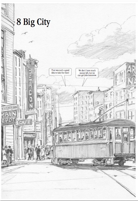
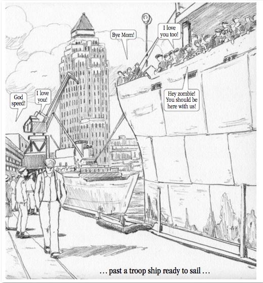
Other Vancouver landmarks to look out for include the Marine Building, Strathcona Elementary School and the Burrard Bridge.

It’s not necessarily a kid’s book, although it certainly could appeal to teens, and Michael likes the idea that it might help young people make a connection to a time in our history that may feel remote.

Tosh 3

“I wanted to put some important historical facts in there,” he says. “For example the National Selective Service for him, and then the reality of her life, and that really bizarre thing that if Toshiko had married Cowboy she would have been reclassified as white.”

The book launch for Toshiko is at 3:00 p.m. on Saturday July 18 at the Nikkei National Museum and Cultural Centre in Burnaby.

© All rights reserved. Unless otherwise indicated, all blog content copyright Eve Lazarus.

Online Porn for History Nerds

the_title()

When I was researching my 2007 book At Home with History I spent most of my life at the Vancouver Archives and on the 7th floor of the Vancouver Public Library. Now, instead of trekking downtown, much of the information is available to me here at home.

Today, the digital world just got a bit better with the launch of three very cool new online toys.

Goad's Fire Insurance Map 1912
Goad’s Fire Insurance Map 1912 showing the DTES

Goad’s Fire Insurance Map

Vancouver Archives has made the Vanmap even more exciting by adding a layer from a 1912 Fire Insurance Plan. Once onto Vanmap click on aerial imagery and you’ll see Goad’s Fire Insurance map. Michael Kluckner took me for a digital tour of his Grandview neighbourhood of 1912 where we found an “Isolation Hospital,” a huge estate called Wilga, and Brook House, complete with its turret. I zoomed into the DTES with CVA archivist Heather Gordon and we could see all the 1912 businesses and brothels along Alexander Street as well as a sawmill and police station, and the original shoreline shown in dashed lines.

The map is colour coded—yellow represents wood framed buildings and the pink are brick and stone—mostly in the downtown area. See Sue Bigelow’s post for a clear description of all its uses.

2636 Trinity Street
Heritage Site Finder Map

Heritage Site Finder Interactive Map

I’ve spent hours playing on this interactive map by the Vancouver Heritage Foundation. The map lists buildings and landmarks found on the Heritage Register—(and eventually other buildings not on the register) and there are around 2,300, many with photos and descriptions. It’s incredibly easy to navigate and you can search by address, zoom into an area, or just click on houses at random. This is a work in progress, so if you click on a building and can’t find a photo, keep trying. Better still if you have old photos of the building and information, send them to the VHF so they can add them. Eventually it will also be possible to add long demolished buildings so we can see how Vancouver looked through a historical filter.

digital building permits

Historic Building Permits online database

You’d think answering a question like ‘when was my house built?’ would be simple. It’s not. Or at least it wasn’t until Heritage Vancouver Society started to transcribe thousands of building permits (currently at 33,000) from the Vancouver Archives prior to 1929—the year Point Grey and South Vancouver amalgamated into the City of Vancouver. Before these permits were online—and it is a volunteer-dependent work-in-progress—you would have to go to the Archives and look through pages and pages of handwritten ledgers brought out to you in huge bound books. With the online database you can pull up every house built in a block, you can search for every building designed by a certain architect, or most impressive and simplest of all, you can find out when your house was built.

© All rights reserved. Unless otherwise indicated, all blog content copyright Eve Lazarus.

Vancouver’s Odlum Family and their Fabulous Houses

the_title()
Home of Professor Edward Odlum
The Odlum family at 1774 Grant Street ca.1908

It was Anzac Day in Australia yesterday, an important national holiday back home that honours those who fought and were slaughtered at Gallipoli on April 25, 1915. I was thinking of this when John Mackie’s story in the Vancouver Sun today caught my eye. A 12-page letter written by Victor Odlum and dated May 1, 1915 had found its way to MacLeod’s Books almost a century later. In the letter, which included his hand-drawn maps, Victor wrote about the battle of Ypres which took place between April 22 and went on until the end of May.

Victor had sent the letter to his father Professor Edward Odlum via a friend to circumvent the censors. It’s a graphic account of the battle that left 2,000 Canadians dead and another 4,000 wounded.

“Four days without sleep, under too tense a strain to eat, and fighting all the time, day and night, under heavy shellfire, was trying,” wrote Odlum.

Built for Matthew Logan in 1910
2530 Point Grey Road

The Odlums were an interesting family. Odlum Drive in Vancouver’s Grandview area was named after Edward. According to Michael Kluckner’s Vancouver: The Way it Was, Edward helped produce the first electric light and the first public telephone in Canada while still at university. His passion was comparative ethnology and he travelled the world to study tribes in Australia and the South Pacific.

Edward built the fabulous turreted house at 1774 Grant Street around 1908.

Victor was born in 1880, fought in the Boer war at age 19, and on his return to Vancouver went to work for L.D. Taylor at the World. By 1905 he was editor-in-chief. When war broke out in 1914, Victor was in the first wave of Vancouver volunteers who went to France. Kluckner writes that he was a prominent advocate of Prohibition, and earned the nickname Pea Soup Odlum for replacing the soldiers’ rum ration with soup in the trenches.

Victor lived near his father’s house in Grandview before and on his return from WW1. He was also a financial whiz and was the Odlum behind Odlum Brown, a brokerage house founded in 1923. He bought the Vancouver Star around the same time. In the late ‘20s he traded up from his modest house at 2023 Grant Street and moved to Kitsilano. Later he and his wife moved to Rocklands at Whytecliff in West Vancouver.

In 1941 Victor was appointed High Commission to Australia. He died in 1971 aged 90.

© All rights reserved. Unless otherwise indicated, all blog content copyright Eve Lazarus.