


We’ve been taking advantage of the lack of traffic on the roads to take Pickles, our Chiweenie on some new trails. This week we ended up in North Burnaby, parked at the bottom of Boundary and walked along the Trans Canada Trail to Willingdon.
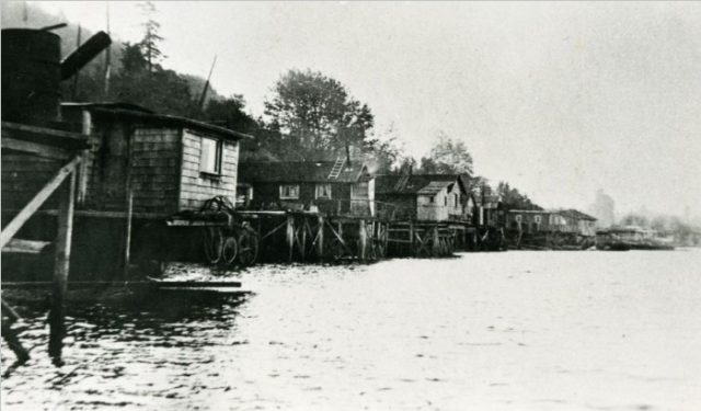
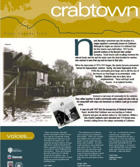
While I’m familiar with the squatters at Maplewood Flats and Cates Park on the North Van side of Burrard Inlet, I’d never heard of Crabtown, a collection of squatters’ homes built on raised pilings between the railway tracks and the water.
According to the plaque—all that’s left of Crabtown—it was built by sawmill workers during a housing shortage around 1912. When the Depression hit in the ‘30s, families moved in and Crabtown grew in size and population. By 1957, the little town had 130 people living in over a hundred houses. That year, the National Harbours Board evicted the lot for squatting on federal land, and demolished their homes.
Dan Francis has done quite a lot of research on the history of squatting in Burrard Inlet and has gathered up first-hand accounts of the area.
One of them, he writes on his blog, was by the late, great Chuck Davis who moved to Crabtown in 1944 when his dad paid $300 for a shack along the boardwalk. Chuck told Dan that he loved the place and when a train went by the whole shack trembled.
If you’d like a sense of what living in a squatters’ community is like, check out Finn Slough
© All rights reserved. Unless otherwise indicated, all blog content copyright Eve Lazarus.


I had already decided that I would ask for a picture of a Chiweenie. Thanks for including one, she is very adorable. We have walked our Pomchi from the Barnet Marine Park towards the Iron Workers bridge. ( I do not approve of changing names of public property but second narrows wasnt really a name)
I know we either ran out of energy or perhaps trail but we got as far as the Capital Hill . Its getting harder and harder to walk anywhere interesting these days. While the seawall or Ambelside to Dundarave are fun some of the less developed walks can be worth while
A rewarding walk is Harbourview Park, and here is the link for it:
http://findfamilyfun.com/harbourview.htm
This affords a closeup look at various industries along Lynn Creek, and at the end of the trail there is a lookout tower with a terrific panoramic view of the harbour and mountains. You get a really good look at freighters being loaded. Lots of dog walkers go here. You could also park at Bridgman Park, walk south on the trail along the west side of Lynn Creek and cross over at the Main Street Bridge to the continuation of the trail on the east side.
A wonderful and more challenging walk is Klootchman Park in West Vancouver:
http://findfamilyfun.com/klootchman.htm
I would hesitate to take Pickles there. The narrow lane roads in the immediate neighbourhood are worth exploring.
I grew up in South Van in the 50’s (Columba and Marine Dr.) I remember Finns Slough very well – we used o ride our bikes over the old Fraser River swing bridge and ride all over Sea Island and Lulu Island.
The whitewashing of any culture by out “father knows best” govt saddens me . Were they an impediment to marine traffic? No probably just the fact no taxes were paid was their downfall. I must say the homeless were much more enterprising then than todays lot.
I think they are just enterprising in different ways. I’m sure I wouldn’t last five minutes.
The squatter shacks came down for many reasons, but one to know about was the midcentury trend known as “slum clearance”. Many cities had programs to demolish ghettos, tenements and flophouses to make room for urban highways and new development.
Great article, Eve and interesting about Dan Francis.
My grandparents squatted in North Vancouver at the foot of Forbes Ave until about 1964. They also owned a place in the Gulf Islands and had a marine engineering business, so they live on the cheap in a shack by choice. Very nice waterfront location as well, now occupied by BCIT.
Not sure anyone maintAins it anymore but the south of E. First from just east of Lonsdale all the way to the big sloping road (there is a wild trail to a creek then through the sour end of a park honouring mills and wood people). My dad, Val Roberton maintained that trail for 30 years w/ his neighbour, Osmo.
Where exactly is the “plaque”? I’m trying to figure out where Crabtown actually was; east of IWMB and west of the “white beach” [Confederation Park Beach?] puts it roughly in Montrose Park just north of N Gilmore Ave. Is that correct?