Every Place Has a Story

Riding the Spirit Trail from Pemberton Avenue to the Capilano River (Part 6)

the_title()

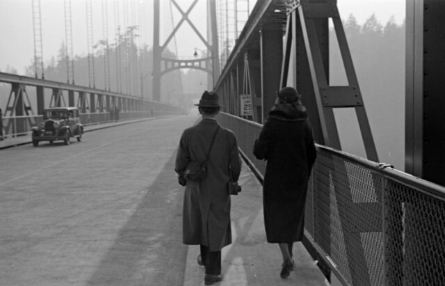
Last week we stopped our ride at Pemberton Avenue. Today we’re going to cross the border into West Vancouver.

The first part of the Spirit Trail winds through Norgate, a quiet neighbourhood filled with mid-century ranchers built during the post-war boom period. But did you know that the whole area was originally intended to be the Capilano Air Park?

A typical Norgate rancher along the Spirit Trail. Eve Lazarus photo, 2018

It was first proposed in 1945 and the idea was that it would cater to tourists flying their own planes from other parts of North America. There would be two runways and construction would  start in 1947 and include luxury accommodation. In the end, we couldn’t afford it and the land was sold to Hullah Construction for a subdivision.

1950s newspaper ad promoting Norgate as a family-friendly neighbourhood. Courtesy NVMA

After we pass through Norgate, it’s a quick ride to the road that leads to the Lions Gate Bridge, built in 1939 by the Guinness brewing family. The provincial government later bought the bridge and the toll came off in 1963.

Now a National Historic Site of Canada. Photo courtesy Vancouver Sun

In 1982, a group of UBC engineering students suspended a Volkswagen Beetle from the bridge. On the first night, a group of students attached a cable under the bridge. On the second night, students drove a jeep towing the reinforced Beetle. The students detached the car, slipped a cable under its roof, attached the other end to the side of the bridge, and pushed the car over the railings.

As we approach the Capilano River and West Vancouver, it’s pretty clear that the district (named by Macleans Magazine as the richest postal code in Canada last year) is not spending its net worth on the Spirit Trail. In fact, it’s lack of enthusiasm is downright dangerous as you cross the bridge that takes you over to Ambleside.

But in 1913, it wasn’t cars that you had to worry about. The sand and gravel that washed down the Capilano River had built up on the north side of First Narrows to such an extent that ships were grounding, especially in bad weather. In July of that year, George Alfred Harris became the first lightkeeper at the newly constructed First Narrows Lighthouse.

The Capilano Fog and Light Station 1914. Coutesy WVA 0032.WVA.PHO

The lighthouse, and the keeper’s house sat on pilings at the mouth of the Capilano River, and except for very low tide, the Harris family was surrounded by water. The lighthouse operated until 1968.

Top photo: Walking over the Lions Gate Bridge in 1939. Courtesy CVA 260-995

© All rights reserved. Unless otherwise indicated, all blog content copyright Eve Lazarus.

Next time, we’ll be riding through Ambleside and along to Dundarave where the Spirit Trail ends for now.

If you’ve missed any of the rides, please see:

The North Shore’s Spirit Trail – Moodyville (part 1)

Moodyville to Lonsdale Quay (part 2) 

Lonsdale Quay (part 3)

Mosquito Creek (part 4)

Harbourside (part 5) 

West Vancouver (part 7)

The Capilano Air Park

the_title()
1950s newspaper ad promoting Norgate as a family-friendly neighbourhood, courtesy North Vancouver Museum & Archives

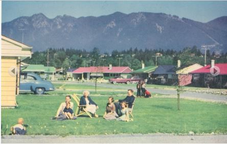
From Vancouver Exposed: Searching for the City’s Hidden History

A few people that I know have sold their large houses and downsized to Norgate, one of the few flat areas of North Vancouver just to the east of the Lions Gate Bridge. Norgate is also one of the few areas that hasn’t seen massive change to its housing stock—a collection of modest-sized, tidy mid-century ranchers with big gardens. And that’s exactly the appeal to those not willing to settle for a condo or multi-floored townhouse with strata fees and councils attached.

And, as it turns out, Norgate has a really interesting history—the area was originally planned to be the Capilano Air Park.

Norgate
Proposed airfield appeared on a 1947 map of North Vancouver, courtesy North Vancouver Museum and Archives

According to the North Vancouver Museum and Archive’s March 2006 Express, the new airfield was first proposed in 1945, and designed to cater to tourists flying their own planes from other parts of Canada and the U.S. Plans were to have two runways— the first, a 3,000-foot landing strip for light aircraft and another 2,500-foot runway for heavier craft to be added later. Construction was supposed to start in 1947 and include luxury accommodation for the “flying tourists.”

Sowden Street, Norgate ca.1950, courtesy North Vancouver Museum & Archives

In the end, there weren’t enough funds available for an airfield and the land was sold to Hullah Construction to develop a subdivision. Company namesake, Norman Hullah, modeled Norgate after a typical California subdivision, building houses on a scale of 50 at a time and working out of a mill located in the area.

Typical Norgate rancher today