Every Place Has a Story

The Giant Georgia Street Pylons of 1967

the_title()
Courtesy Vancouver Archives, 1967

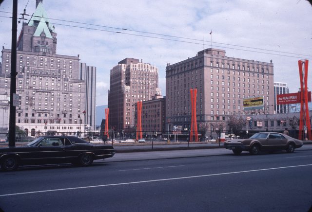
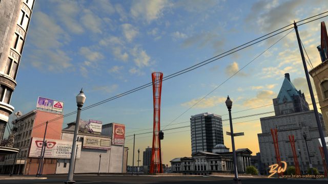
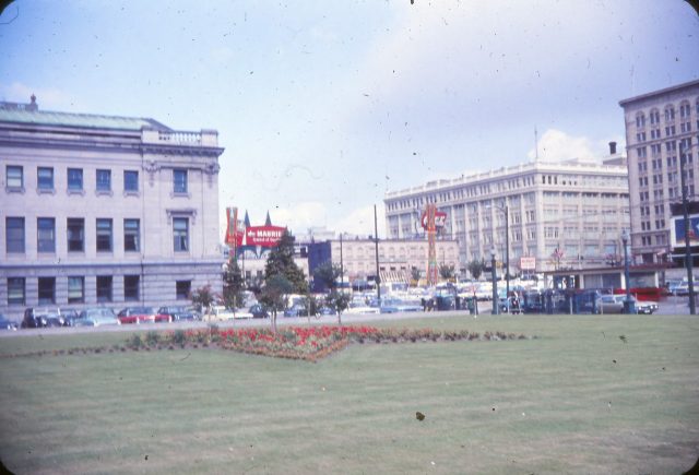
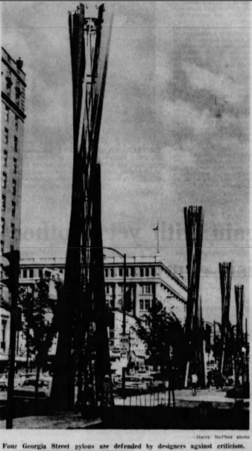
If you lived in Vancouver in the late 1960s, you’ll likely remember the four bizarre red Georgia Street pylons. The pylons ran from Granville to Howe Streets between July 1967 and December 1969.

According to a news media release at the time: “The 60-foot towers, symbolic of giant torches, a traditional heraldic device, are a fitting expression for Canada’s 100th birthday.”

From Brian Walters virtual reality film: Granville and Georgia: 150 years
Reaction:

Not surprisingly, the pylons which ran between Granville and Howe Streets, brought out intense emotions. Mayor Tom Campbell thought they looked like “crashed airliners.” He took a bunch of reporters to look at them in the Cambie Street city works in his city-paid limousine and told them: “This is a scrap dealer’s field day, we bought $32,000 worth of junk.” “Tom Terrific,” as the mayor was not affectionally known as, added that it cost taxpayers “$100 a foot.”

Photo by Peter Thorne, 1967. Courtesy Angus McIntyre
Centennial Committee:

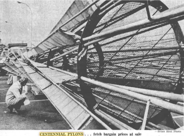
The Pylons which were organized through the Vancouver centennial committee, cost $32,000 (over $270,000 in today’s dollars). Designed by structural engineer Boguslaw Babicki and industrial designer Rudy Kovach, they were roughly the size of a four-storey building. Made from steel pipe and lit by 44 spotlights and a dozen 1.5 million-candle-power searchlights, each pylon was decorated with twelve 60-foot strips of nylon material. Each one weighed in at 3,000 pounds and was set in concrete footings.

“I predict that they’ll be the most distinctive thing about Vancouver this summer for tourists and citizens alike, and I’ll bet you they’re used again with different decorations,” Rudy Kovach told the Province. Well, sorry Rudy, they weren’t.

Vancouver Sun, December 8, 1969
Sold off:

Ben Wosk picked up all four pylons for under $3,000. He bought them for a $10 million development at Whistler (which never eventuated). Wosk outbid five others including Arnold Schuck, who wanted to turn the pylons into giant scissors to advertise his furniture business.

An anonymous buyer paid $10 each for four steel Maple Leaf frames with light sockets that were attached to the pylons.

So, the question is – where are the pylons now?

Province, July 5, 1967

With thanks to Angus McIntyre who suggested the story and provided most of the research.

Sources:

Vancouver Sun, June 27, 1967 “’$100 a Foot for Junk,’ moans Mayor of Towers”

Province, July 5, 1967 “You Can’t Measure Art”

Vancouver Sun, December 7, 1971 “Bleachers bought for fencing.”

Province, December 8, 1969 “A different kind of fire sale.”

© Eve Lazarus, 2022

Pacific Centre

the_title()

When the Pacific Centre took over Granville and Georgia Streets, it knocked out blocks of heritage buildings.

Story and photos from Vancouver Exposed: Searching for the City’s Hidden History

Angus McIntyre got this shot in 1974 by leaning out of a window on the top floor of the Birks Building. The Granville Mall was under construction, and Eaton’s had just opened.
The Great White Urinal:

When I moved to Vancouver from Australia in the mid-1980s, locals had already had a dozen years to get used to Pacific Centre and the “Great White Urinal”—the name they’d not so affectionately dubbed the Eaton’s department store building. But it wasn’t until several years ago when I saw a 1924 photo showing the Strand Theatre, the Birks Building and the second Hotel Vancouver lined up along Georgia at Granville, that I realized how much we had lost.

In the 1970s, the Scotia Tower and Vancouver Centre took out the Strand Theatre and the Birks Building. CVA Str N201.1 1924

In the 1960s, city council wanted a redevelopment of downtown Vancouver with Georgia and Granville Streets as the epicentre. The fear was that the downtown core would lose business to suburban malls and the hope was that a new, modern shopping centre would attract people and breathe life back into that intersection. The thought was that this retail vibrancy would come through a superblock and underground parking that spread across several blocks.

In this photo taken by Angus McIntyre at a similar angle to top photo in 2020, you can still see the BC Electric building and part of St. Paul’s Hospital. Missing includes King George High School and Dawson Elementary
Superblock:

The superblock was made up of Block 52—bounded by Granville, Georgia, Howe and Robson; and Block 42—bounded by Granville, Georgia, Howe, and Dunsmuir. The problem was that the T. Eaton Company, which owned all of Block 52, wasn’t in a hurry to move from West Hastings (now SFU Harbour Centre) and a new department store was essential to anchor the proposed shopping mall.

Newly bulldozed Block 42 in 1973 and the 30-storey TD tower that replaced the parking lot that replaced the second Hotel Vancouver. CVA 23-24

The other problem was 18 individual landowners owned Block 42 and none of them wanted to sell. By the fifth redevelopment report in July 1964, a frustrated city council led by Mayor William Rathie were figuring out ways to expropriate their land.

An aerial view early 1960s showing the future site of the Pacific Centre and Robson Square. CVA 516-32
Vancouver’s Greatest Day:

In May 1968, the city held a plebiscite to allow them to buy up all the properties in Block 42 and 70 percent of voters agreed. The next mayor, Tom Campbell, told the press: “We’ve got a united city which wants a heart. Vancouver had only a past—today it has a future. This is Vancouver’s greatest day.”

The Eaton’s Marine Room had an outdoor patio that looked out onto Howe Street. Angus McIntyre took this photo in 1979 – you can still see the part of the Devonshire Hotel and the Georgia Medical Dental Building on West Georgia in the background.

By 1974, we had the Pacific Centre and Vancouver Centre shopping malls, much of it as an underground bunker. We’d rid the streets of gorgeous brick buildings and gained the IBM tower, the former Four Seasons Hotel, the Scotia Tower and a 30-storey black glass monument to capitalism in the TD Tower. Rather than revitalize the Granville and Georgia intersection, we sucked the life right out of it.

Related:

The Second Hotel Vancouver: What were we thinking?

Vancouver’s missing heritage buildings

Vancouver Exposed: Searching for the City’s Hidden History

© All rights reserved. Unless otherwise indicated, all blog content copyright Eve Lazarus.

Riding the Spirit Trail to West Vancouver Part 7

the_title()

Lots of history to cover on this last leg of the Spirit Trail. We’re starting at Park Royal, which when it opened in 1950, was the first covered mall in Canada.

Prior to 1965, most of the land you’re riding on was swamp. Ambleside Beach is the product of 85,000 cubic metres of sand and gravel hauled from the sandbanks west of Navvy Jack Point. The pitch-and-putt is built on sawdust, bark and wood waste from a North Vancouver sawmill, and the duck lagoon used to be part of a slough.

Ambleside Beach, 1918. Courtesy WVA

If you look to the right, you’ll see the Ambleside Youth Centre*. Before that it was the West Vancouver Rod and Gun Club, and before that it was one of 18 huts built by the Department of National Defence with four gun emplacements and anti-aircraft guns to defend the harbour entrance below the Lions Gate Bridge during World War 11. After the war, the District of West Vancouver bought the huts and converted them into housing for war vets and their families.

Ambleside Pool opened in 1954 and was gone by 1977. Courtesy WVA 1954

The huts were built on low land that flooded several times a year, and at those times, food and supplies were brought in by rowboat. By 1961, three were moved to the high school for classrooms and the others were destroyed.

Ferry Building, courtesy District of West Vancouver

You’ll come out onto Argyle Avenue and soon see the Ferry Building. Before it was a quaint little art gallery, it was the headquarters of West Vancouver’s ferries which operated until 1947 from a dock at the foot of 14th Street. On a good day, the ferry trip to Vancouver took 25 minutes. Too bad we don’t still have service.

You’ll pass the imposing 16-foot high Welcome Figure that faces Stanley Park—a gift from the Squamish Nation to the people of West Vancouver in 2001.

Silk Purse. Courtesy District of West Vancouver

And then you’ll see the Silk Purse—one of the last examples of the summer cottages that used to dot the area before the Lions Gate Bridge opened in 1938. Built in 1925, former Vancouver Mayor Tom Campbell inherited the cottage from his father, and in 1969, sold it to John Rowland. Rowland’s son him he was trying to make a silk purse out of a sow’s ear. The name stuck and he rented out the Silk Purse as a ‘honeymoon cottage’ for $12 a night, including breakfast and champagne. The District of West Vancouver has owned the Silk Purse since 1991 and it is operated by the West Vancouver Community Arts Council.

NavvyJack/John Lawson house in 1957. Courtesy WVA

You’ll soon be at John Lawson Park, named for the man known as the “father of West Vancouver.” John was a mover and shaker in the West Vancouver business community. In the early 1900s, he bought Navvy Jack’s former house (1768 Argyle) and lived there until 1928. The house—the oldest on the North Shore—is unrecognizable from old photographs. Another victim of demolition by neglect.

Navvy Jack/John Lawson House 2018. Eve Lazarus photo

*The building was demolished in March 2019

  • Top photo: Park Royal Shopping Centre in 1949

With thanks and gratitude to North Vancouver Museum and Archives. 

If you’ve missed any of the rides, please see:

The North Shore’s Spirit Trail – Moodyville (part 1)

Moodyville to Lonsdale Quay (part 2) 

Lonsdale Quay (part 3)

Mosquito Creek (part 4)

Harbourside (part 5) 

Pemberton to Capilano River  (part 6)

© All rights reserved. Unless otherwise indicated, all blog content copyright Eve Lazarus.