Every Place Has a Story

More Photos of Kitsilano in the 1970s and ’80s

the_title()

Last week’s blog on Kitsilano featuring Bruce Stewart’s photos, brought back memories and a healthy does of nostalgia from those of you who were lucky to have known Kits in the ‘70s.

In this week’s blog I’m delighted to bring you photos from Angus McIntyre, Gord McCaw, Peter Dobo and a couple more from Bruce, interspersed with your comments.
Kitsilano in the '70s
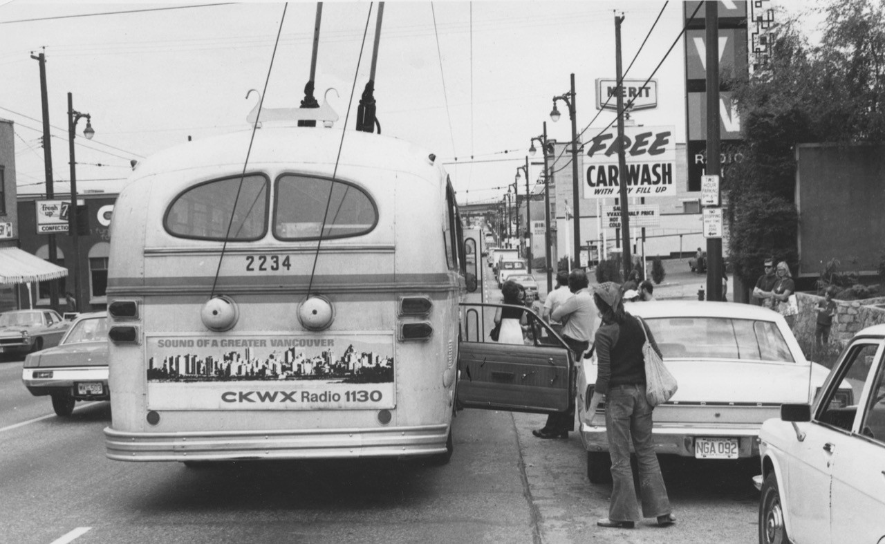
Some things never change: don’t open your car door in the path of a bus – brill or otherwise. Cypress Street and West 4th Avenue, outside CKVN (CFUN), 1973. Angus McIntyre photo

Says Angus McIntyre: “Sam Angel the “Mattress Man” was across the street. He paid for the first New Year’s Eve free rides in 1974, and got his name on the front of every bus.”
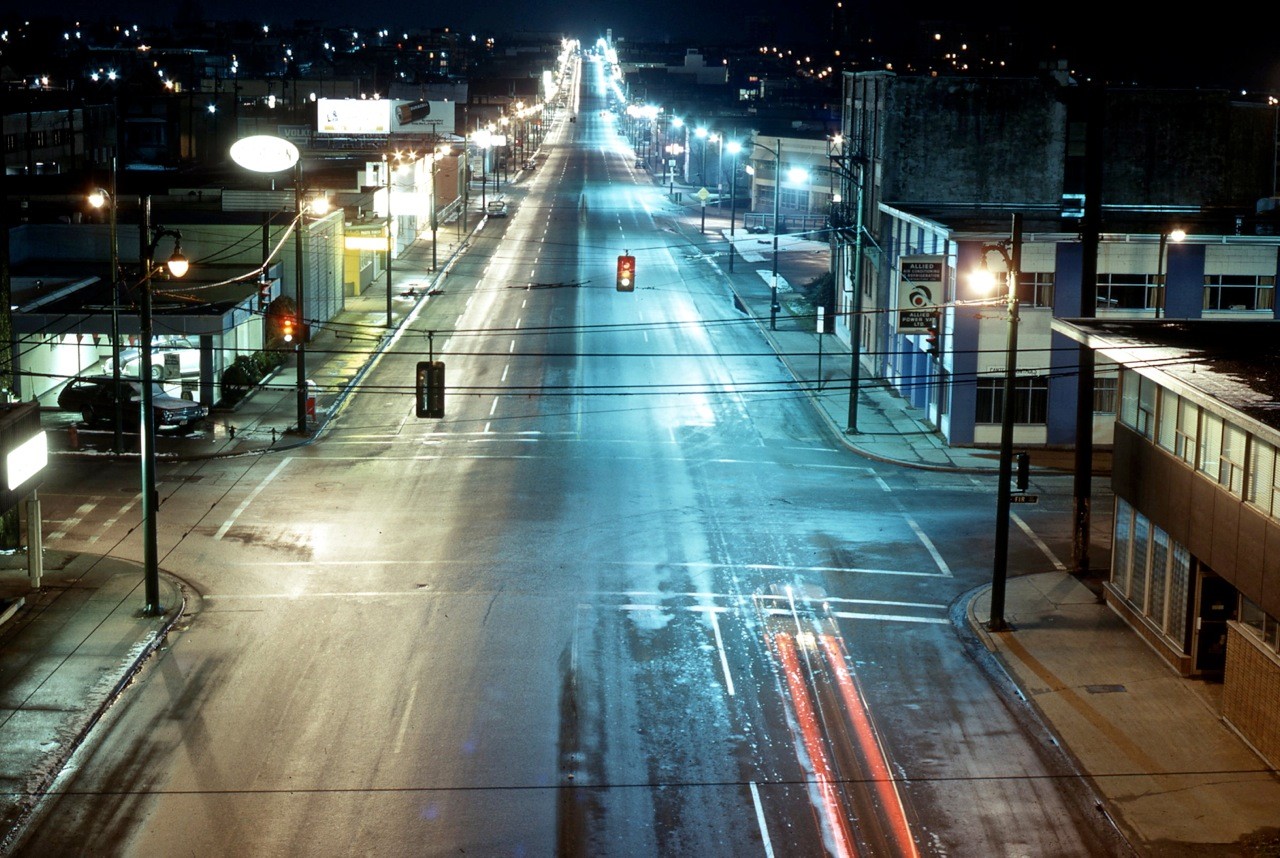
Looking west on 4th Avenue from the Fir Street off ramp on the Granville Street Bridge around 1:00 am. Angus McIntyre photo, mid-1970s

“This view was taken in the mid-1970s as the City of Vancouver converted street lighting from incandescent (on the left side of the street) to mercury vapour (on the right side),” says Angus. “This shows how the night time appearance of the city changed. But little did we know what was in store a few years away- the scourge of orange sodium vapour lighting.”
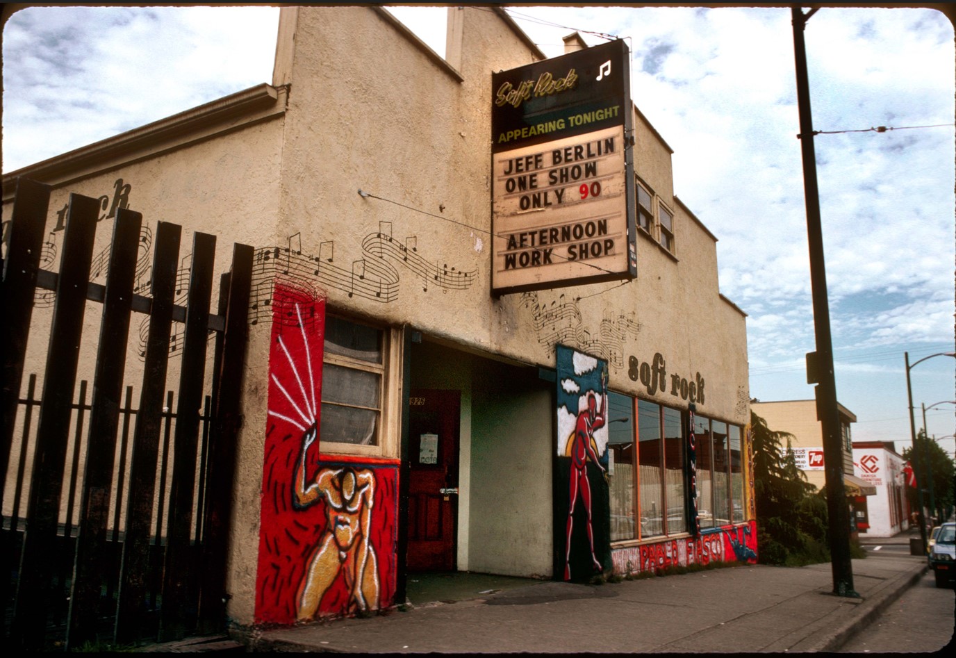
Soft Rock Cafe, 1924 West 4th, early 1980s. Artwork by Pablo Fiasco, photo by Gord McCaw
Music:

“I spent a lot of time in Kitsilano in the late 60s and through much of the 70s. I was there the July day when the Grateful Dead, who were in town for a three-day gig at Dante’s Inferno on Davie, were about to play a free concert near Engine 374 at Cornwall and Yew,” says Mark. “A couple of bands played first, then the neighbours complained about the noise, the cops showed up and the Dead, who’d been hanging around for an hour waiting to play (I stood next to Jerry Garcia, watching as, seated on a picnic table, he give guitar tips to a number of aspiring players), took off along with the rest of us, disappointed.”
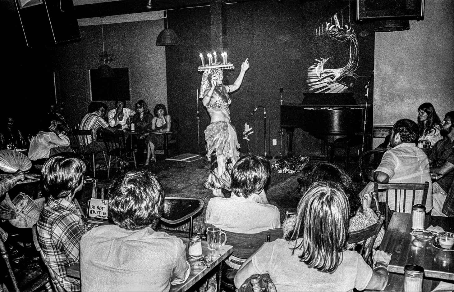
Kitsilano in the 1970s
Soft Rock Cafe, 1925 West 4th, Gord McCaw photo, 1979

“Mom and John lived on the top floor of 1872 W. 3rd. They had the Hippogryff Store beside the Stuart Building on W. Georgia & Stanley Park at the time. I moved down to live with Mom in 1967,” says William who was 10 at the time. “I had all the freedom I could wish for, it was a pretty magical time.”
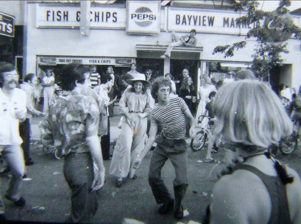
Kitsilano in the 1970s
The first Greek Days on Broadway. Peter Dobo photo, 1974
The Beach:

“I used to live in Kits Point at 2080 Creelman Ave., a duplex with view of Kits Beach with all the beautiful people depicted in Bruce Stewart’s photographs,” says Thomas. “The bakery on Yew and Cornwall with all the wonderful breads and pastry and all the great restaurants along Yew and Cornwall. Lifestream was the melting point where you always met someone you knew. Saturdays we went to the only liquor store up on West Broadway to buy a gallon bottle of Calona wine (tasted horrible) and to find out where the parties were happening. Life was truly beautiful.”
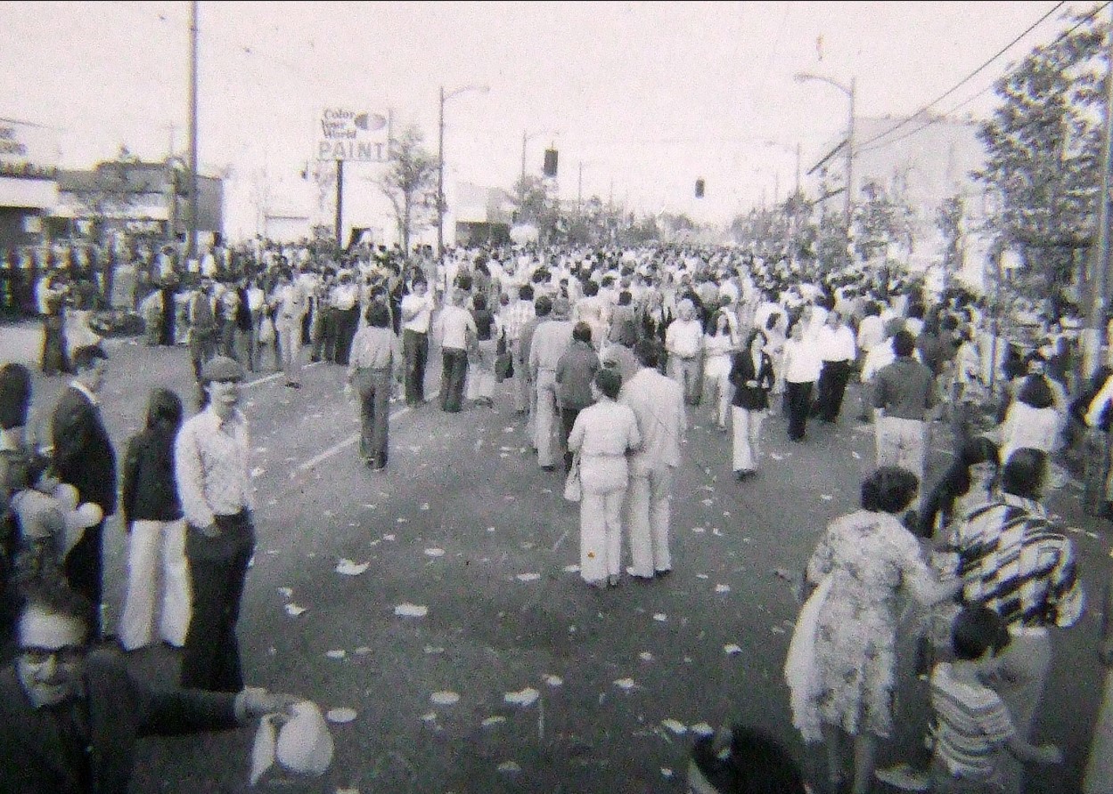
Kitsilano in the 1970s
The first Greek Days on Broadway. Peter Dobo photo, 1974
Landlords:

“In 1969-70, I lived at 2nd and Arbutus in an old wooden, three-storey house basement suite. I was 16 yrs old. The landlords were two ‘eccentric’ brothers Percy and Wes. They were retired, and Wes had worked for the CPR. They were hoarders, and there was canned food stacked everywhere,” says Nick. “The house was full of valuable antiques. Percy gave me a WW2 German Navy flag with the Swaztika on it. I gave it to a collector neighbour in East Van whose son was a friend of mine. Do you remember that HUGE rock that sat on the S.E. corner of 4th and Arbutus? The hippies used to sit on it.”
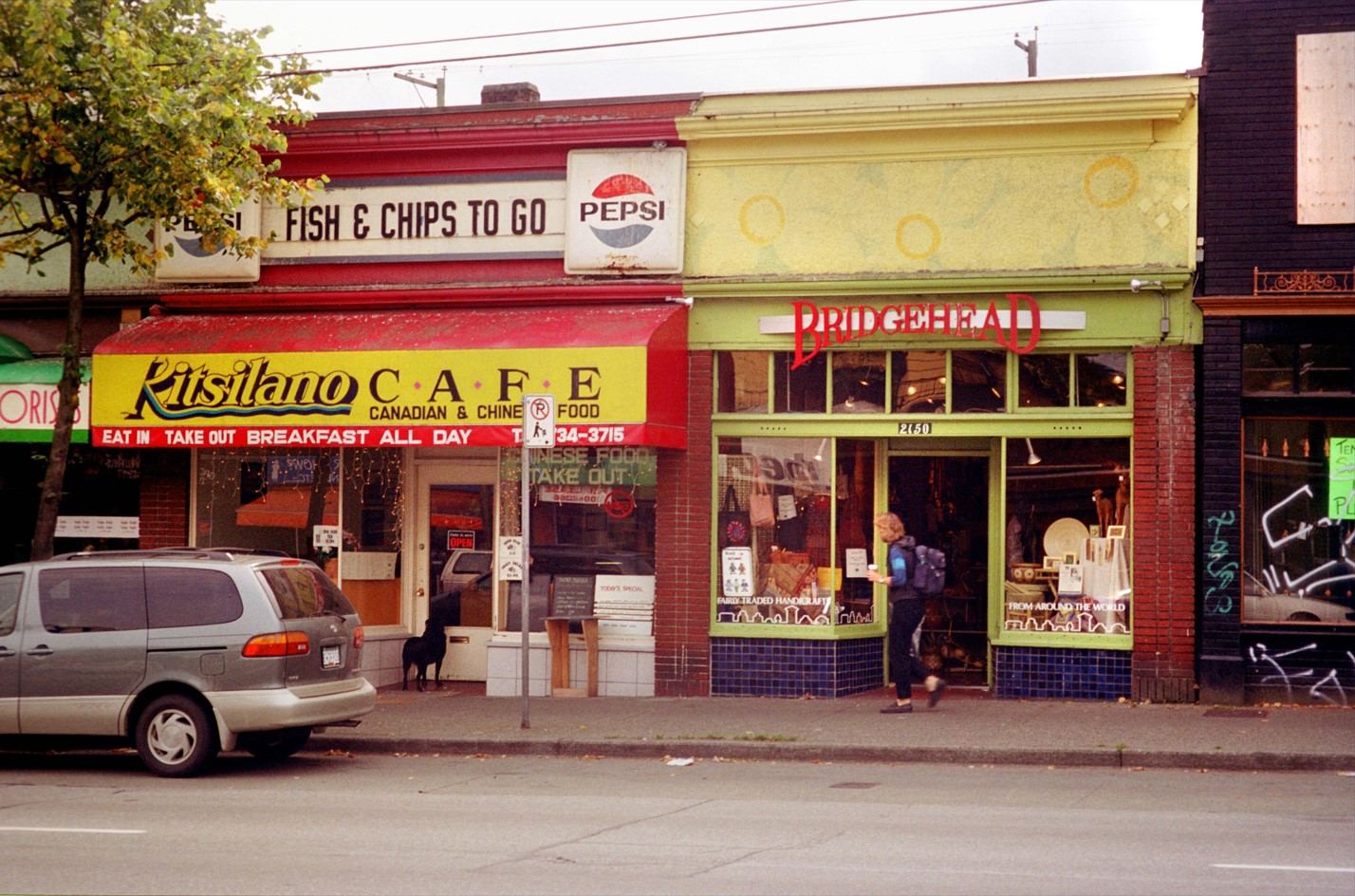
Kitsilano in the '80s
West 4th between Yew and Arbutus Streets early 1980s. Gord McCaw photo

“I worked at the Lifestream warehouse. I used to pick up Peter in my VW van in White Rock and he would meditate on the floor during the commute to Richmond sometimes toppling over with sharp turns,” says Rob. “Lots of odd and funny hippy stories about the warehouse and the restaurant on 4th, my hangout. I’m still a health food freak!”
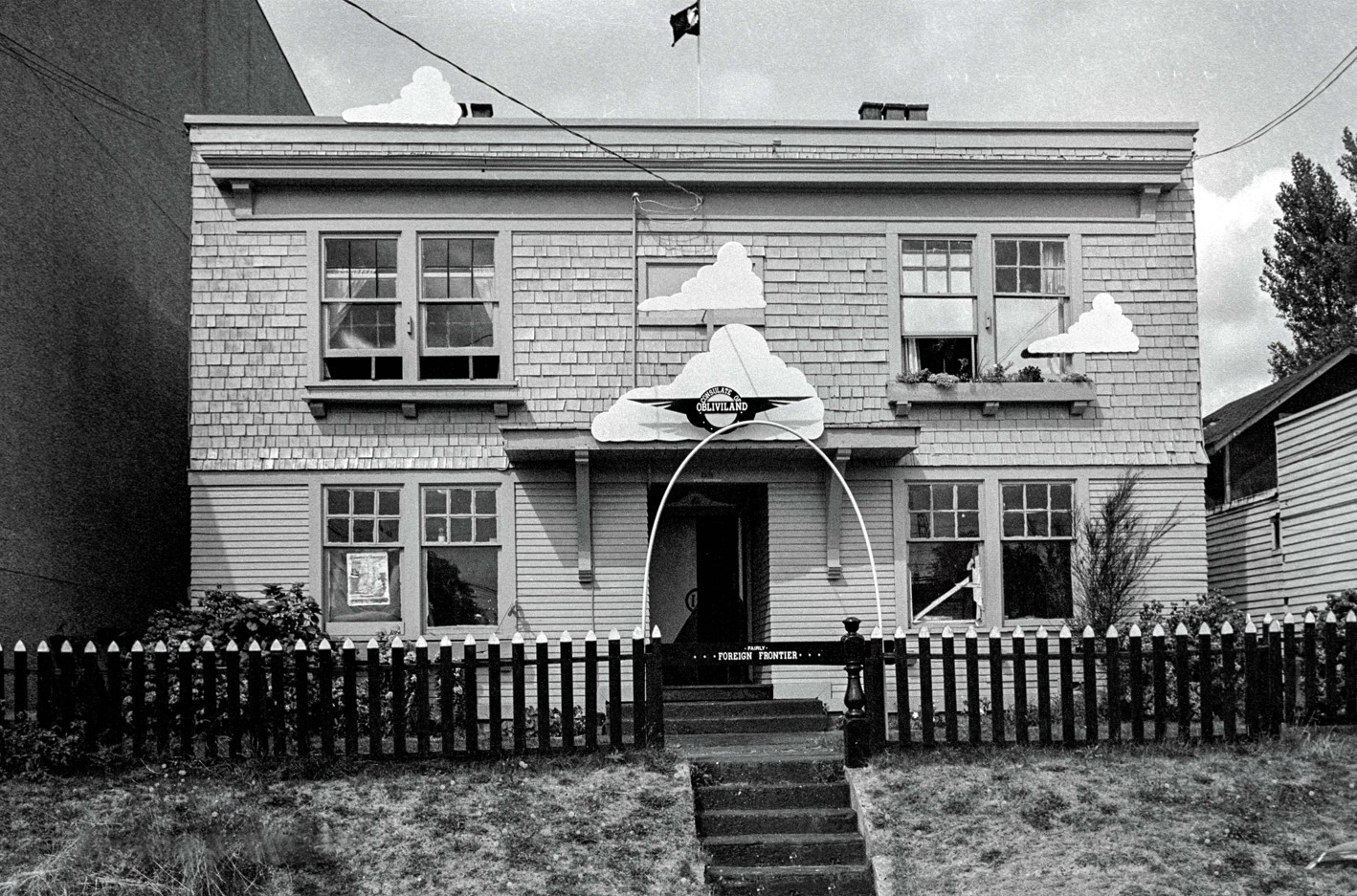
Kitsilano in the 1980s
Birkdale Apartments, 1984. Gord McCaw photo

“I shot several photos of the Birkdale Apartments at 2235 West Broadway over a three year period,” says Gord McCaw. “There was an artists’ colony there and they decorated it in a few different incarnations.”

Bulletin Boards:
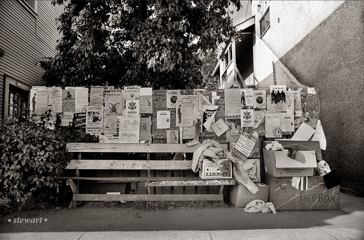
Kitsilano in the 1970s
Bulletin board a few blocks west of Burrard, just off 4th Avenue. Bruce Stewart photo, mid 1970s

Says Bruce: “It appealed to me as it seemed like a one-stop ‘shopping’ setup: notices for everything from experimental theatre, cheap accommodation, yoga, clown workshops, spiritual healing, you name it! And, a place to rest one’s bones and pick over the free merchandise, on offer (the Fourth Avenue Free Box).”

“The Lifestream billboard. It was our internet,” says Will.

Says Jennifer: “It was like Tinder for hippies before social media.”
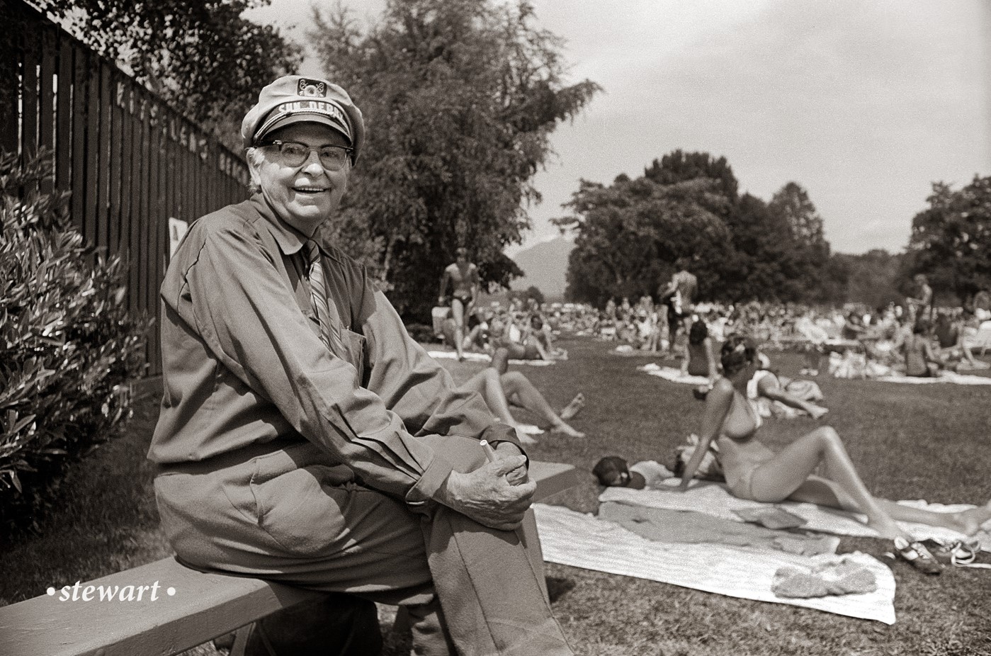
Kitsilano in the '70s
Kits Beach, mid-1970s. Bruce Stewart photo

“I worked at CFUN in the early ’80s,” says Elizabeth. “A regular sight was the local guy with a big boat of a car, who had replaced front and back bumpers with flower boxes and always had his goat in the back seat.”

Related:

© All rights reserved. Unless otherwise indicated, all blog content copyright Eve Lazarus.

The Knight Street Bridge: Part 2

the_title()

The Knight Street Bridge photo essay is the second in a three-part series by Angus McIntyre. The photos were taken on Angus’s Konica Autoreflex T Camera.

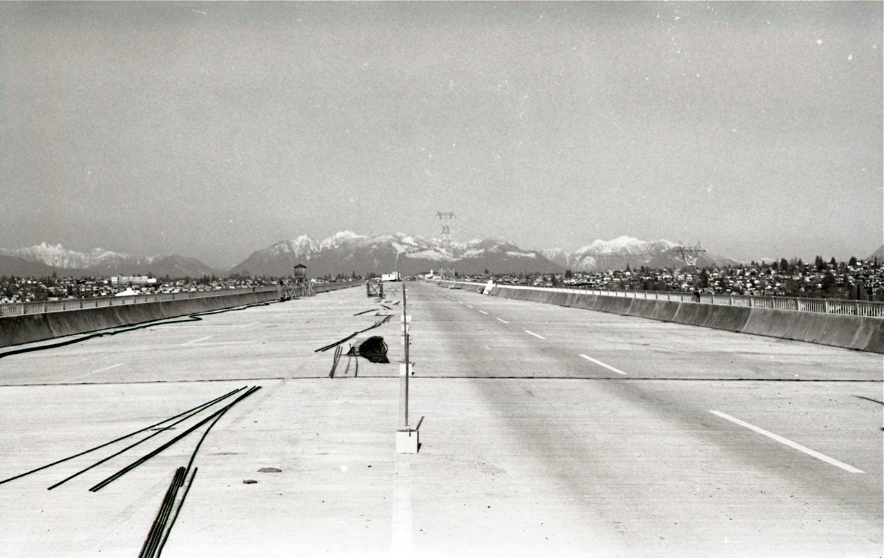
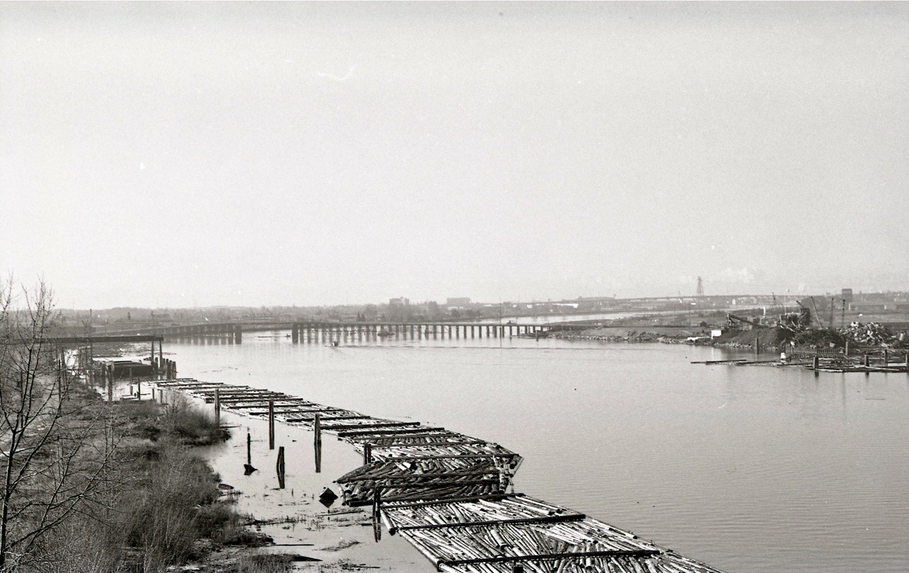
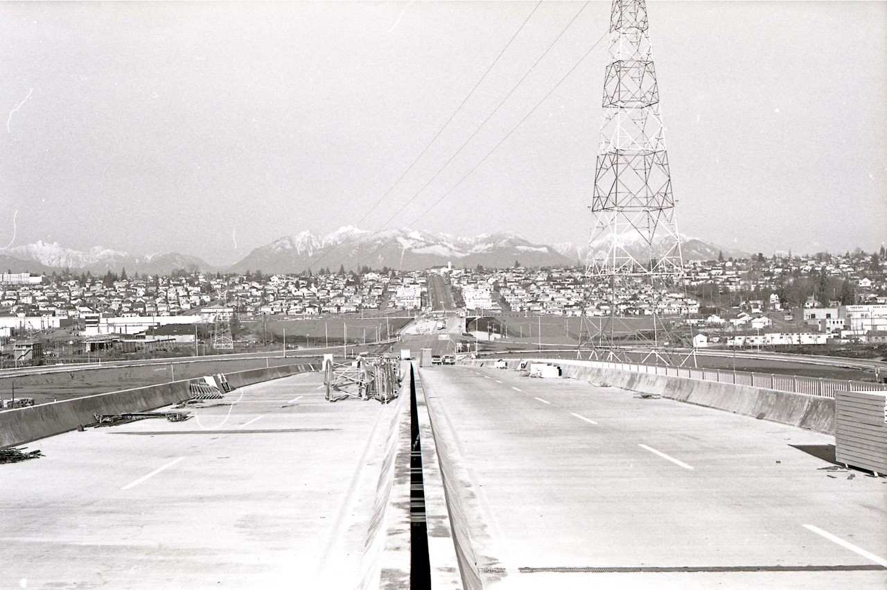
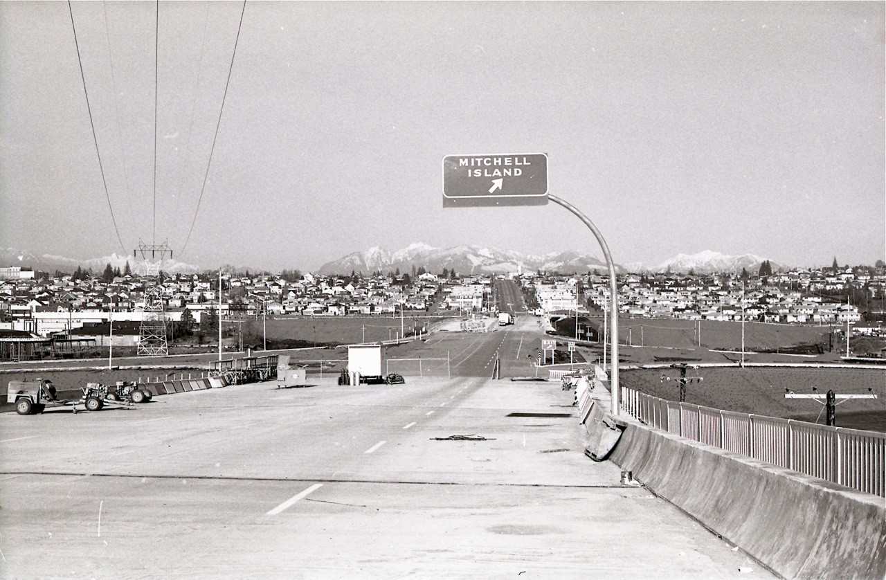
December 31, 1972 was an unseasonably warm Sunday and Angus McIntyre jumped on his bike and headed to the Fraser River. He spent the day documenting the construction of the Knight Street Bridge and the Arthur Laing Bridge – the two Fraser river crossings that would replace the Fraser Street swing span bridge from Vancouver to Mitchell Island and the fixed trestle bridge to Lulu Island.

By Angus McIntyre
Knight Street Bridge
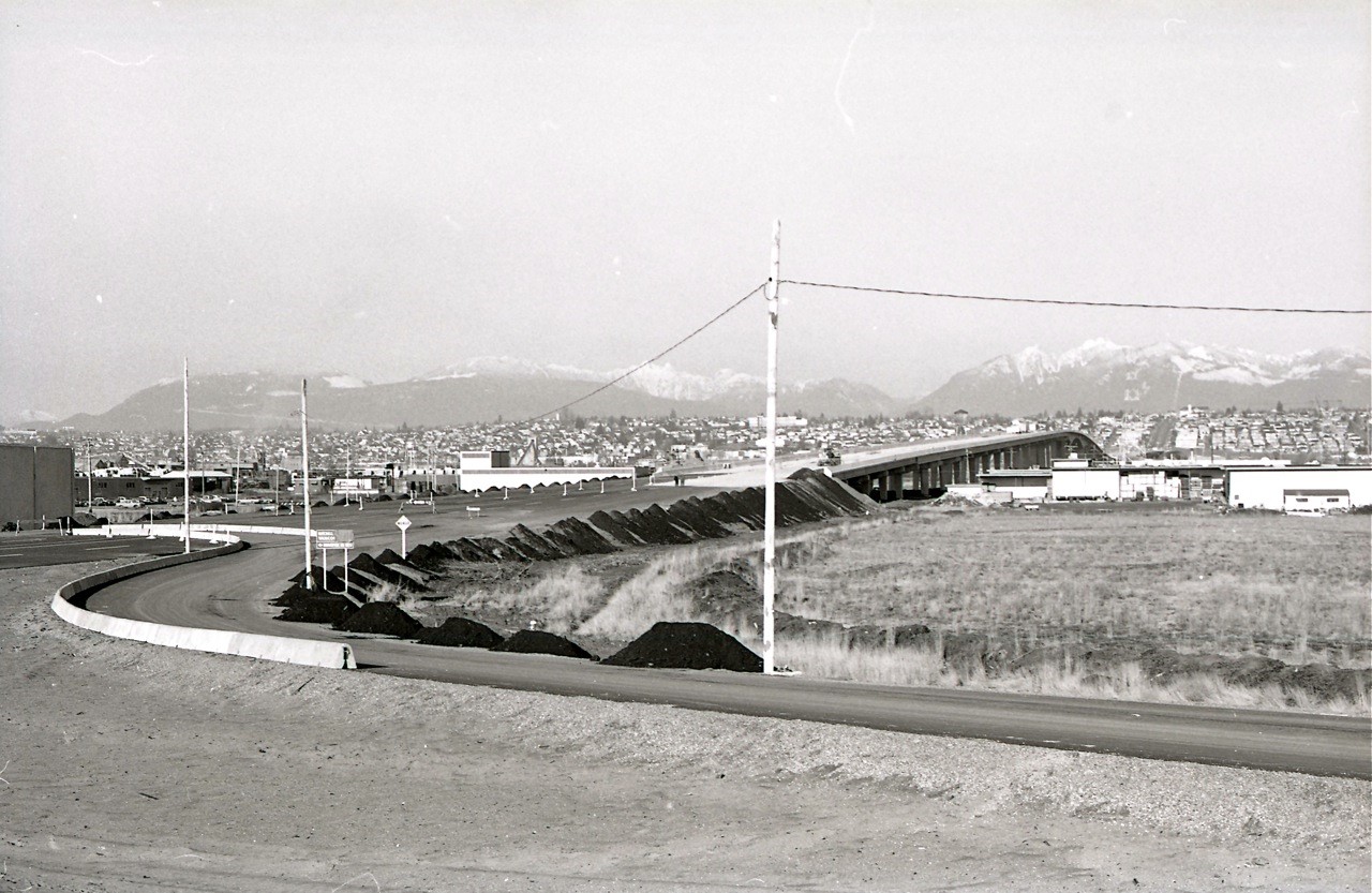
The approach to the south span of the Knight Street bridge from Lulu Island (Richmond) looking north. Angus McIntyre photo, December 31, 1972

Construction on the Knight Street Bridge started in 1969. It was the second cantilever bridge in North America to use cast-in-place segments.

Knight Street bridge
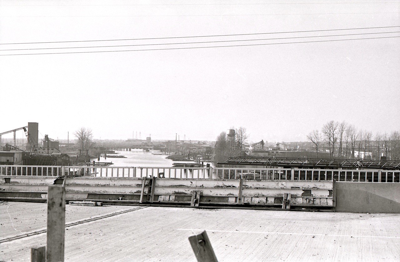
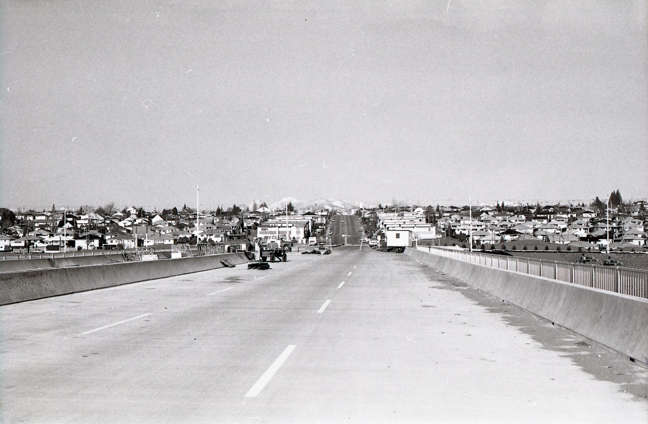
Looking north on the bridge deck towards Mitchell Island. Angus McIntyre photo, December 31, 1972
Knight Street Bridge
View from the bridge deck shows the trestle bridge from Mitchell (Twigg) Island to Lulu Island, with the Oak Street Bridge in the distance to the right. This trestle bridge was hit by a barge in 1966. Angus McIntyre photo, December 31, 1972
Knight Street bridge
Approach to Mitchell Island looking north. The south span is four lanes wide. Angus McIntyre photo, December 31, 1972
Knight Street Bridge
View from the end of the south span arriving on Mitchell Island. North span construction visible. Angus McIntyre photo, December 31, 1972
Knight Street bridge
The six-lane north span of the bridge from Mitchell Island to Vancouver. Angus McIntyre photo, December 31, 1972
Knight Street bridge
Looking west from the north span of the Knight Street Bridge downstream towards the Fraser Street swing span bridge. Angus McIntyre photo, December 31, 1972
Knight Street bridge
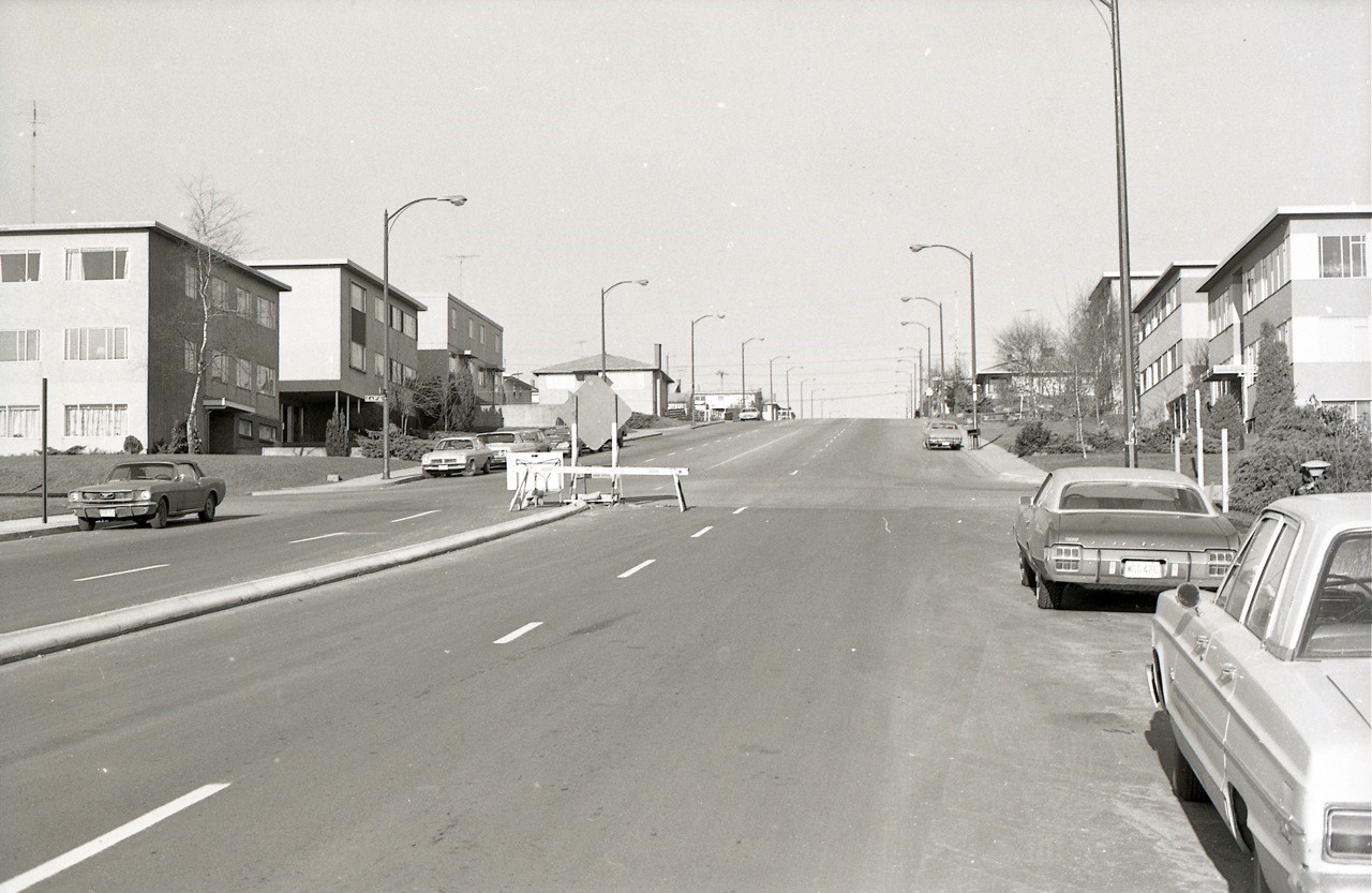
Knight and E. 63rd Avenue – the calm before the storm. Angus McIntyre photo, December 31, 1972
Knight Street bridge
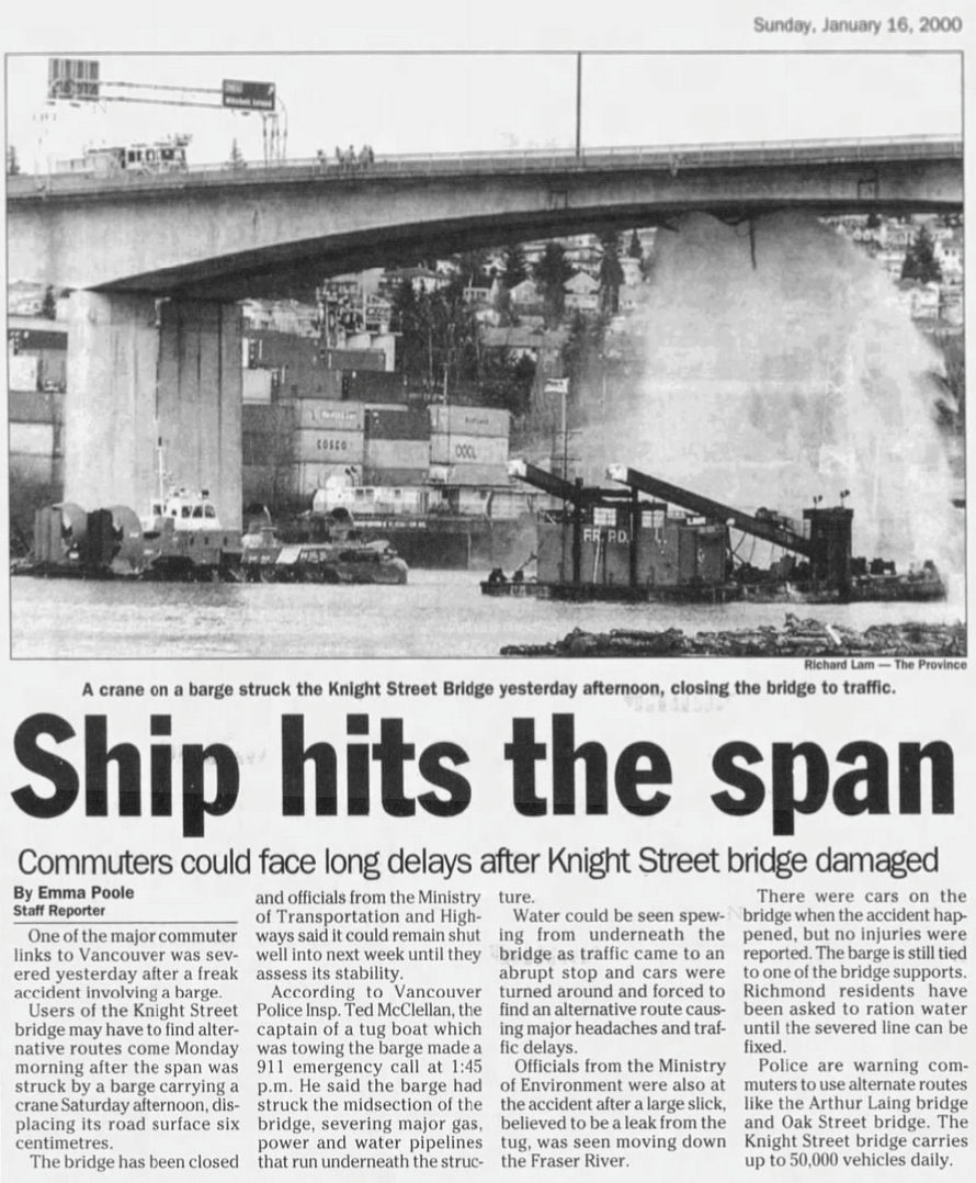
The Knight Street Bridge was closed for 48 hours when a crane on a barge hit the underside of the bridge. Province photo, January 16, 2000.

The bridge opened on January 15, 1974.

Please see: Part 1: The Fraser Street Swing Span Bridge

Next up: Part 3: The Arthur Laing Bridge.

Related:

The Fraser Street Swing Span Bridge

the_title()

The Fraser Street Swing Span Bridge was built in 1894 and linked what’s now Fraser Street with No. 5 Road, Richmond. It was demolished in 1974 after completion of the Knight Street Bridge. This is part one of a three-part series about crossing the Fraser River in 1972 by Angus McIntyre

On December 31, 1972, Angus McIntyre, 25 was living at the Fairmont Apartments at 10th Avenue and Spruce Street. The last day of the year was a mild one, and Angus packed up his Konica Autoreflex T camera, jumped on his 10-speed and headed south. Lucky for us, he had decided to spend the day on a bridge tour—taking photos of the Fraser Street Swing Span Bridge, the Knight Street bridge and the Arthur Laing bridge, both which were under construction.

Angus McIntyre
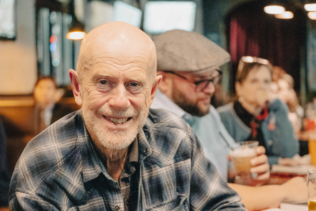
Angus McIntyre at the book launch for Cold Case BC. Scott Alexander photo, November, 2022

Story, photos and captions by Angus McIntyre, who is now 75, still cycling and still taking photos.

Two Bridges:

“If you were a motorist in Vancouver 50 years ago, there were two bridges that you could cross to get to Lulu Island and Richmond – the Oak Street Bridge and the Fraser Street Swing Span,” says Angus. “There were no other bridges until you reached the Queensborough Bridge, although two new ones were under construction.”

Fraser Street
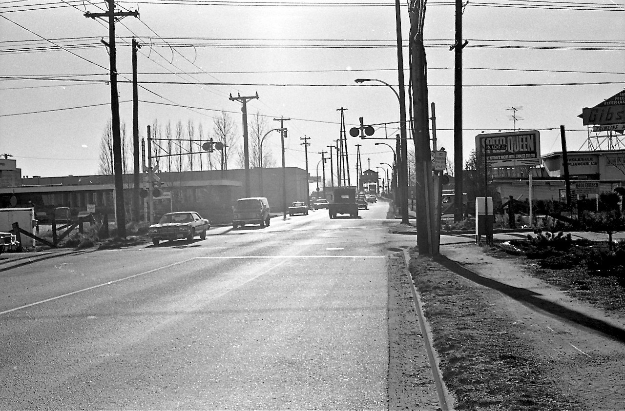
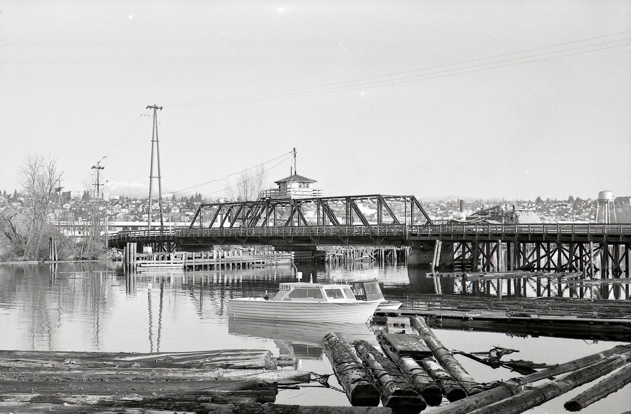
Looking south on Fraser Street at N. Kent Street, just south of Marine Drive. The swing span is in the distance. Angus McIntyre photo, 1972

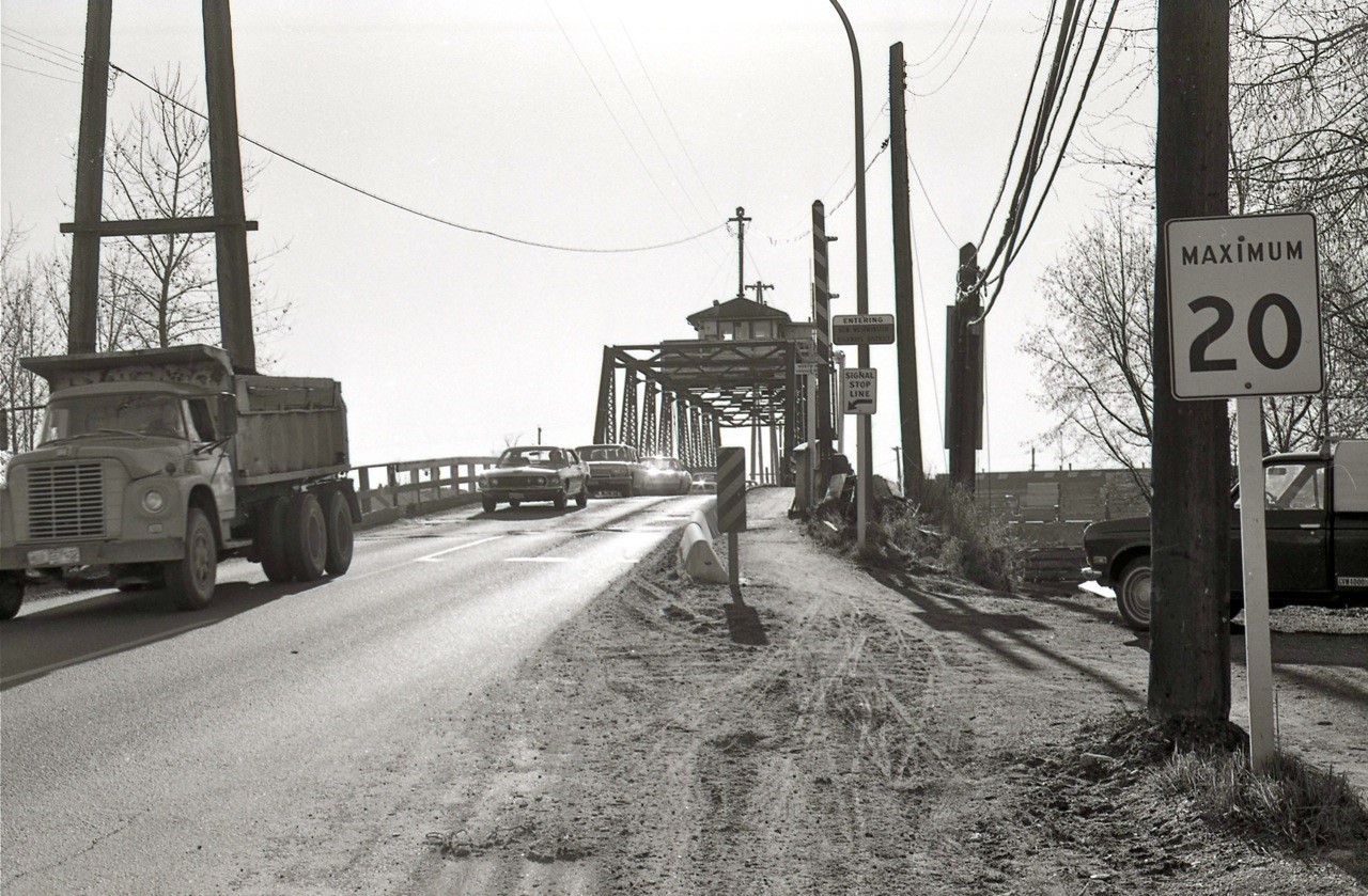
The speed limit sign says 20 miles-per-hour (about 30 km)

Fraser Street
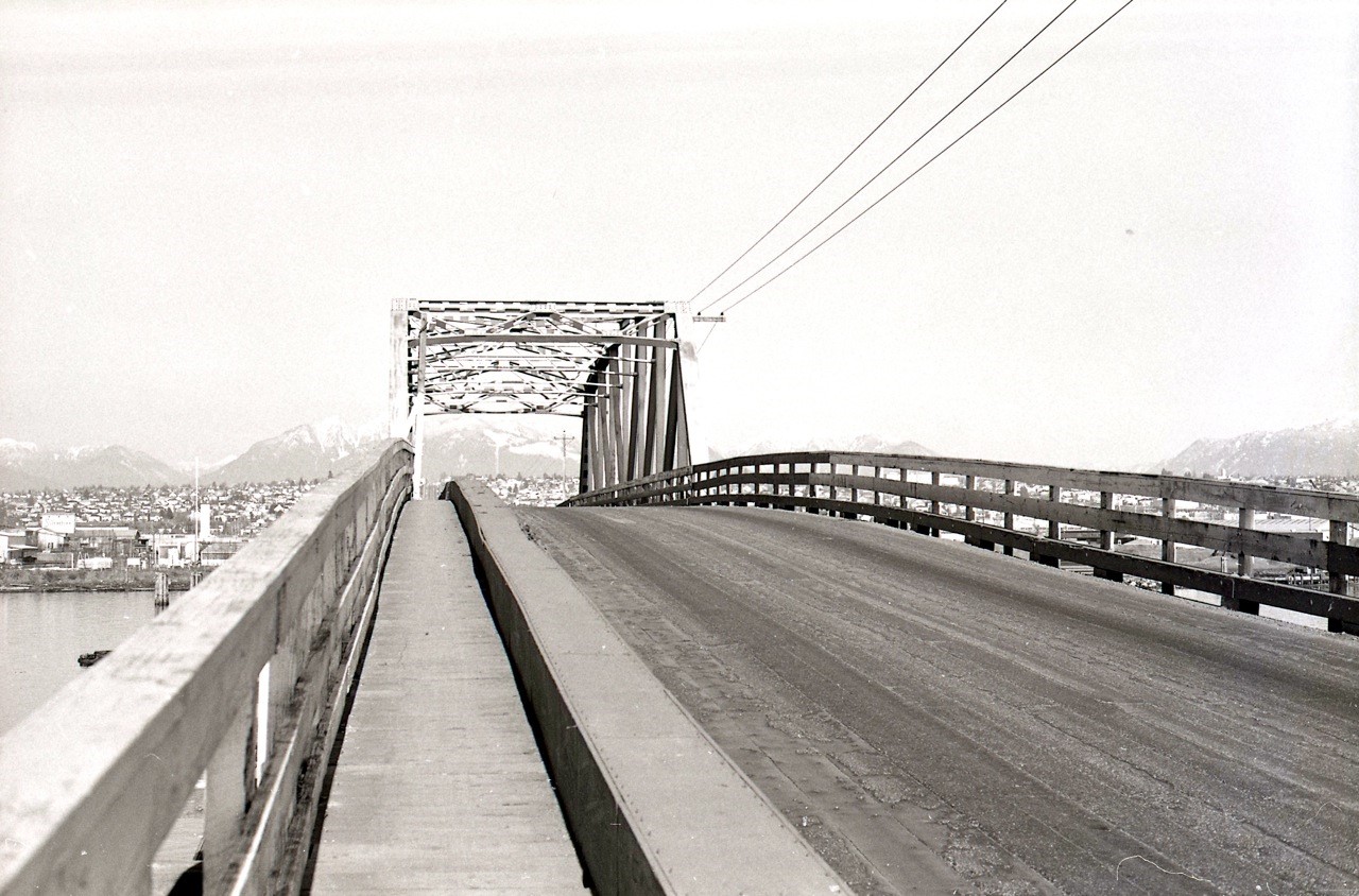
Photo shows the final approach to the Fraser Street swing span bridge from Vancouver. Angus McIntyre photo, 1972

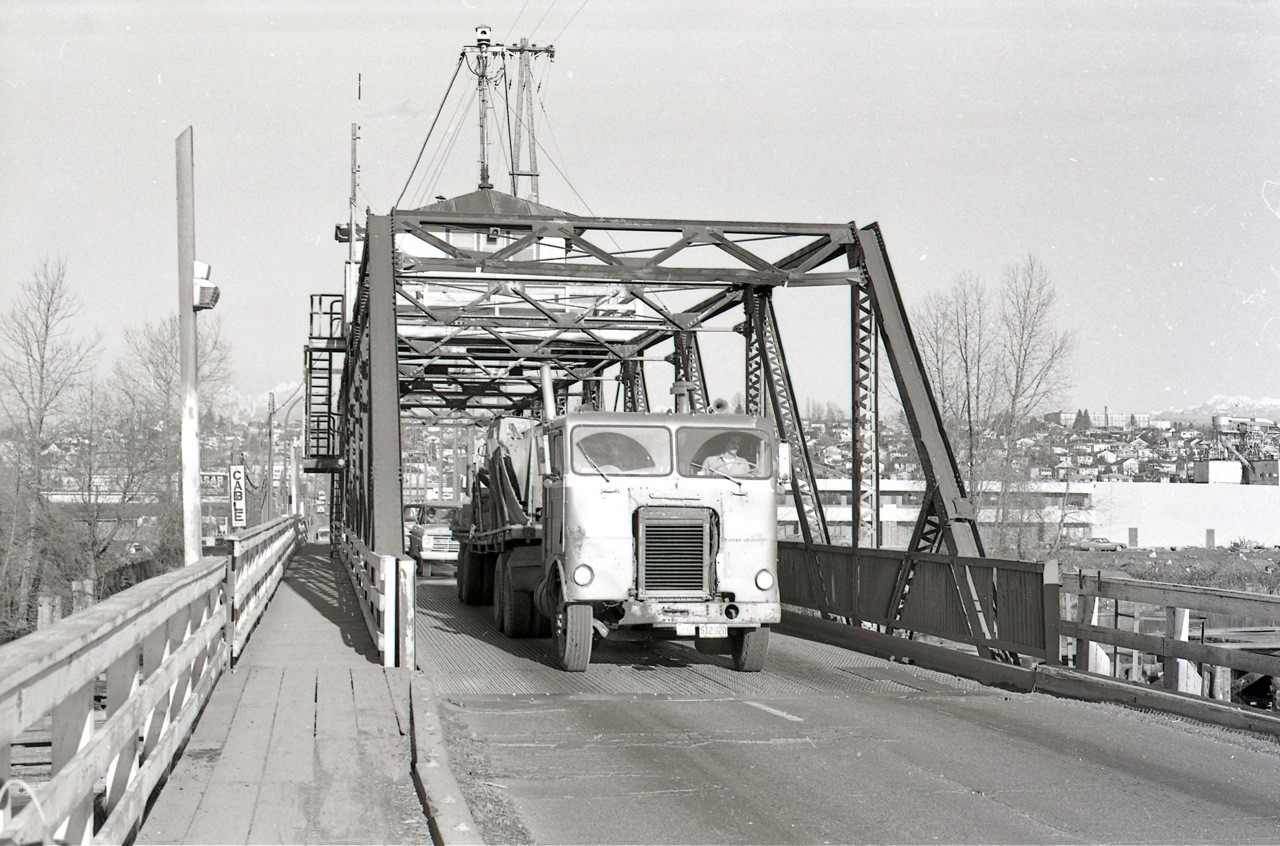
There was just room enough on the bridge for two cars to pass. “The bridge was not wide enough for trucks and buses to enter at the same time as automobiles,” says Angus. “Without any signs warning about this, everyone knew that a truck or a bus had the right of way and opposing traffic would wait until the truck exited the span.”

Fraser Street
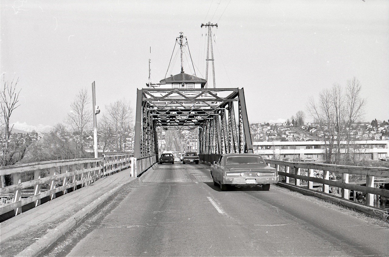
Looking north from south end of the swing span. Angus McIntyre photo, 1972

“The swing span bounced up and down with heavy vehicles,” says Angus. “If it jammed open in the rush hour, the traffic on Oak Street backed up to 41st Avenue.”

Fraser Street
The truck driver has taken the right of way using both lanes. Angus McIntyre photo, 1972
Built in 1894:

The Fraser Street swing span bridge was built in 1894 and lengthened in 1905. Terry Slack grew up on a houseboat at Wreck Beach in the 1950s, and worked with tugs, fishing and boatbuilding on the Fraser. He told Angus: “Tug boats called the channel ‘Shooting the Gap’ in the North Arm and many a tow boat skipper just called it a day, after knocking out one or both of the swing bridges and scaring the hell out of the bridge tenders!”

A bridge tender had a very dangerous job. The crow nest shack was on the opening and closing swing span of the bridge, says Terry. “Making the swing for marine traffic and being stranded in the middle of the channel, praying for the tug and barge to change course, was sometimes a daily happening.”

Fraser Street
Looking north from Twigg/Mitchell Island. Angus McIntyre photo, 1972

Once on Mitchell Island you had to cross a fixed wood trestle bridge to get to Richmond. There were no street lights. If you’d like a sense of what this was like, take a drive out to the Reifel Bird Sanctuary on Westham Island and you’ll cross a single lane swing span wood trestle bridge.

The trestle bridge to Mitchell Island. Angus McIntyre photo, 1972
Barge Smashes into Bridge:

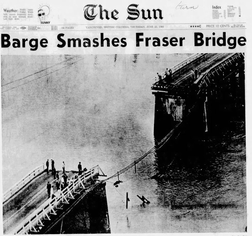
With shades of the English Bay barge mishap last November, on July 23, 1966 a barge struck the centre span of the Fraser bridge punching out a 150-foot section. Six teenage boys who were cycling across the bridge to pick strawberries in Richmond, were thrown into the water and rescued by a tug crew. George Symonds, 27 of North Burnaby was driving his truck across the bridge when he was thrown into the swift flowing river. He survived by smashing his fist through a side window and swimming to the surface.

Vancouver Sun barge smashes fraser bridge
Vancouver Sun, June 23, 1966

Note: I was confused when I searched for information on the swing span bridge and came across the Fraser River Bridge. Angus tells me that this bridge was built for road and rail traffic in 1904, connecting New Westminster with Surrey. It was decommissioned as a road bridge when the Patullo Bridge opened in 1937, but still exists for rail. Road trip!

To be continued with Part 2: Knight Street Bridge and Part 3: the Arthur Laing Bridge.

© All rights reserved. Unless otherwise indicated, all blog content copyright Eve Lazarus.

Related:


The Brill Trolley Buses of Sandon, BC

the_title()
Sandon, 2022
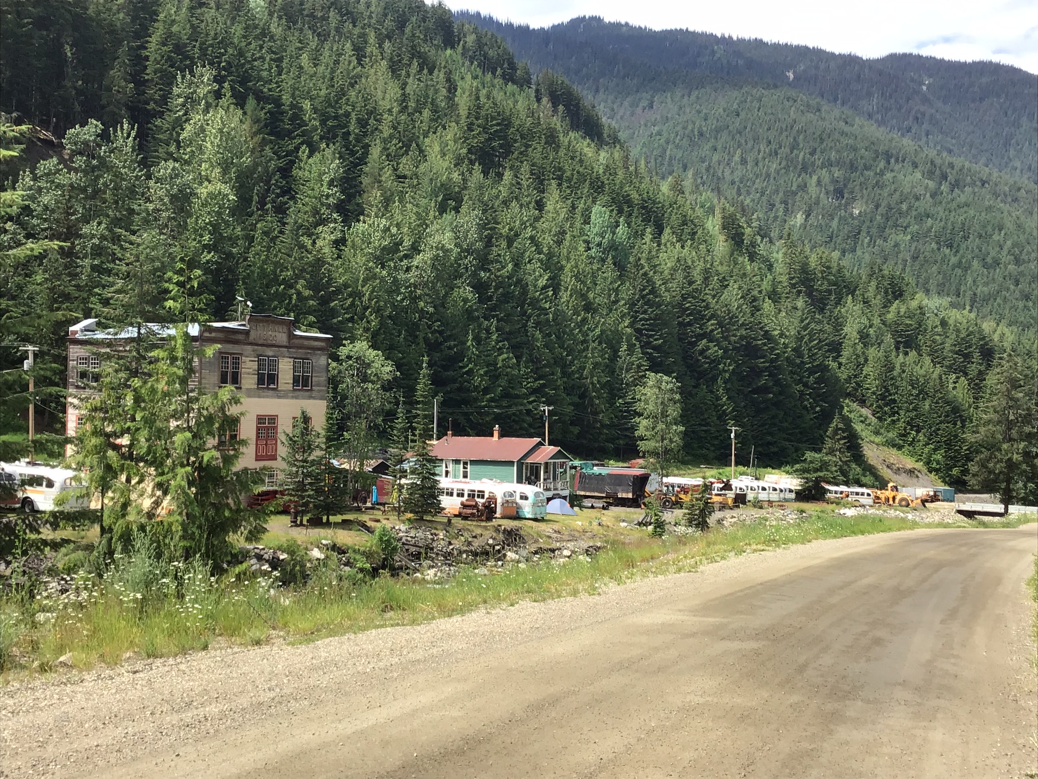
The first thing you notice about Sandon is that the buildings face Carpenter Creek. That’s because in the late 1800s, the town decided to contain the creek in a flume. When the town was rebuilt after a fire in 1900, the creek was boarded over and turned into the main street. Eve Lazarus photo

Thought I’d take a break from my summer break to write up this post about Sandon, a super interesting town in the Kootenays. We dropped by there last week on our way to Nelson because I’d heard it was a ghost town and a graveyard for Vancouver’s Brill Trolley buses. We arrived there via a 10 km dirt road that runs off Highway 31A between New Denver and Kaslo.

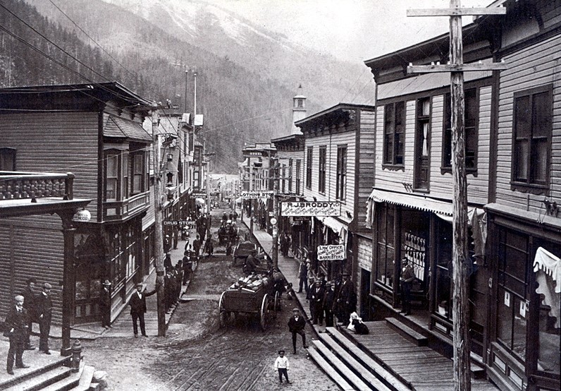
Sandon 1890s
Sandon in the 1890s
Ghost Town:

Sandon is much more than a ghost town and its history is staggering. A century and a couple of decades ago, the Slocan silver rush brought people from all over Canada, California, Colorado, Oregon and Idaho. By the late 1890s, Sandon had 29 pubs, banks, three churches, a major redlight district, a soft drink factory, three breweries, a cigar manufacturer, three sawmills, two newspapers, a bowling alley, a bookstore and an opera house. It also had the most advanced electric light system in North America.

Sandon train
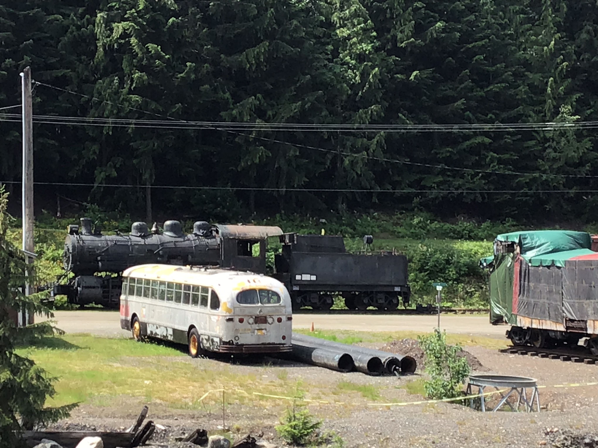
CPR steam engine meets Vancouver Brill Trolley Bus at Sandon. Eve Lazarus photo.
Hal Wright:

We crossed the little bridge over the creek and bumped into Hal Wright who was walking up the road schlepping a ladder. Lucky for us because Hal owns most of the town. He is also an authority on the history of the place—his family settled there in the booming 1890s, and he has lived there since 1972 when he co-founded the Sandon Museum with the help of a government grant at age 16.

Sandon trolley bus
Eve Lazarus photo, 2022

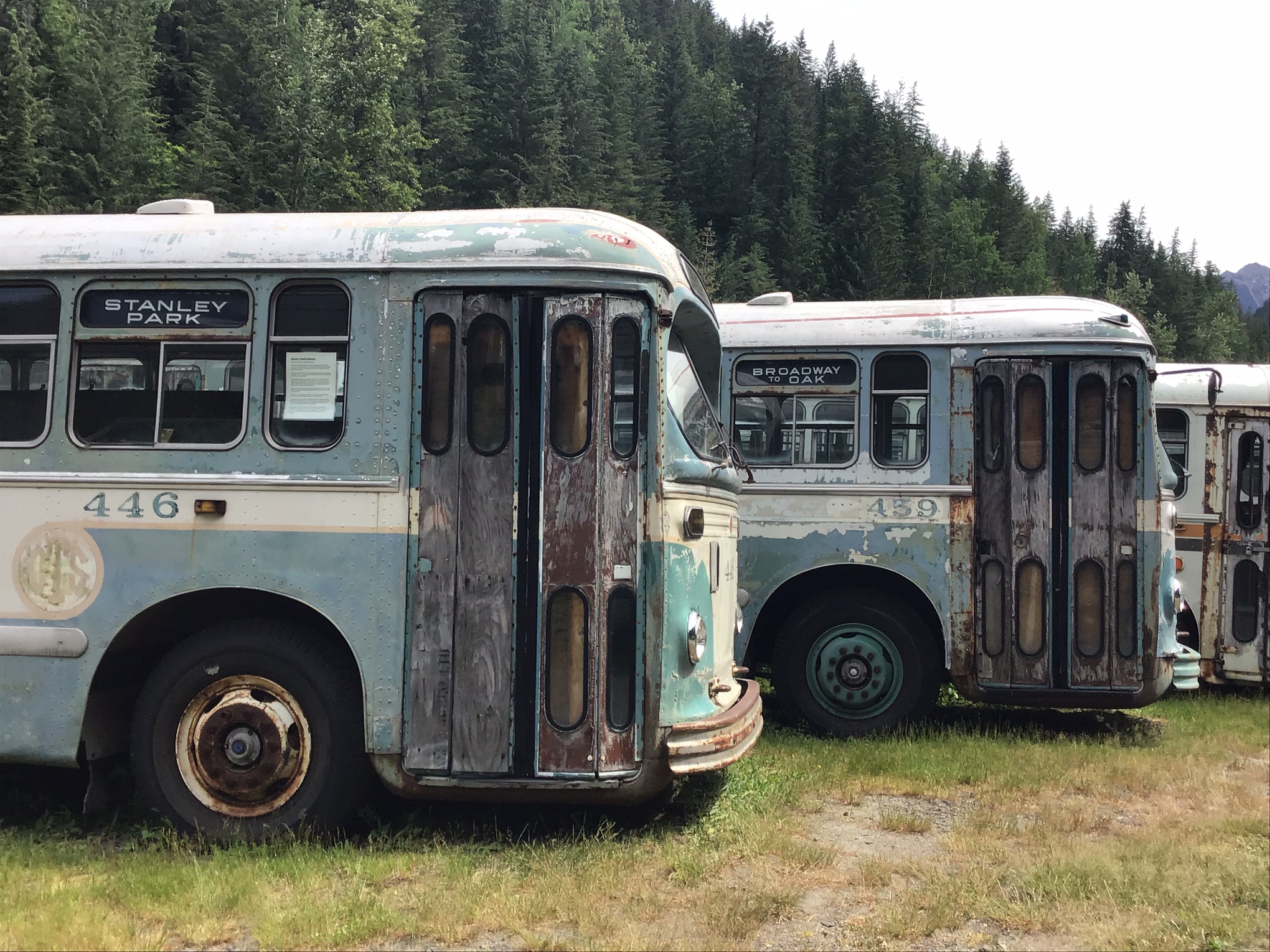
As well as owning a chunk of Sandon land, the 1900 City hall and a steam train, Hal also owns the power station. In 2001, he rescued 13 Brills from the scrapyard, and used his long-haul trucking company to bring them up to Sandon for restoration. The goal, he says, is to put them back into service, probably in Vancouver since that’s the only city in Canada left that still runs electric buses.

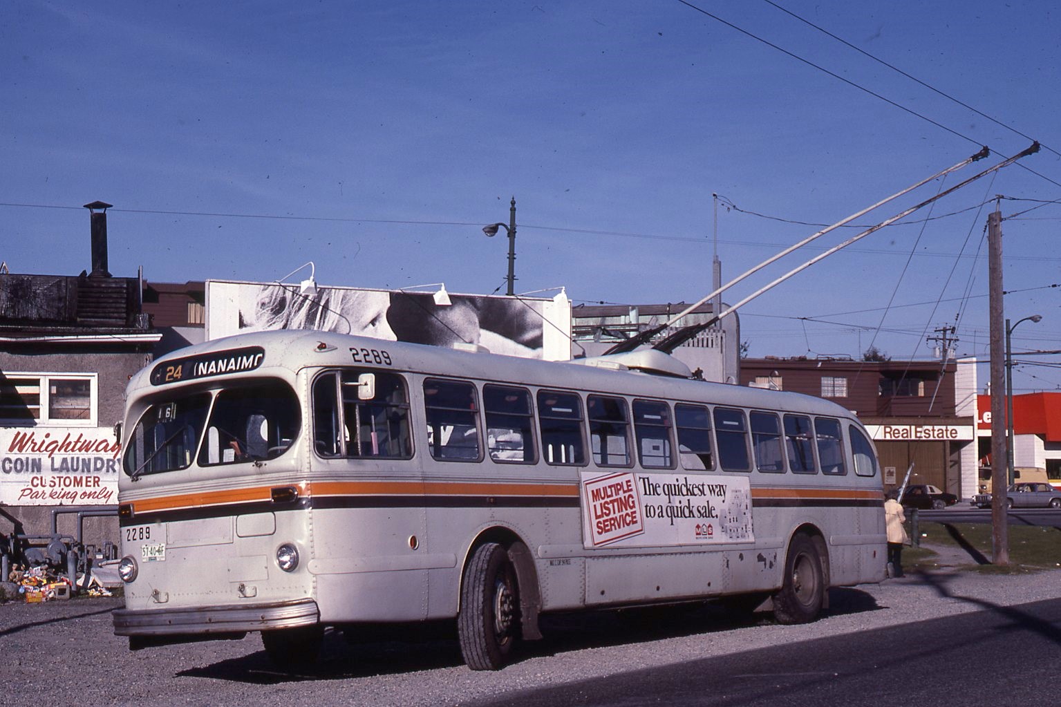
Brill trolley bus 2289
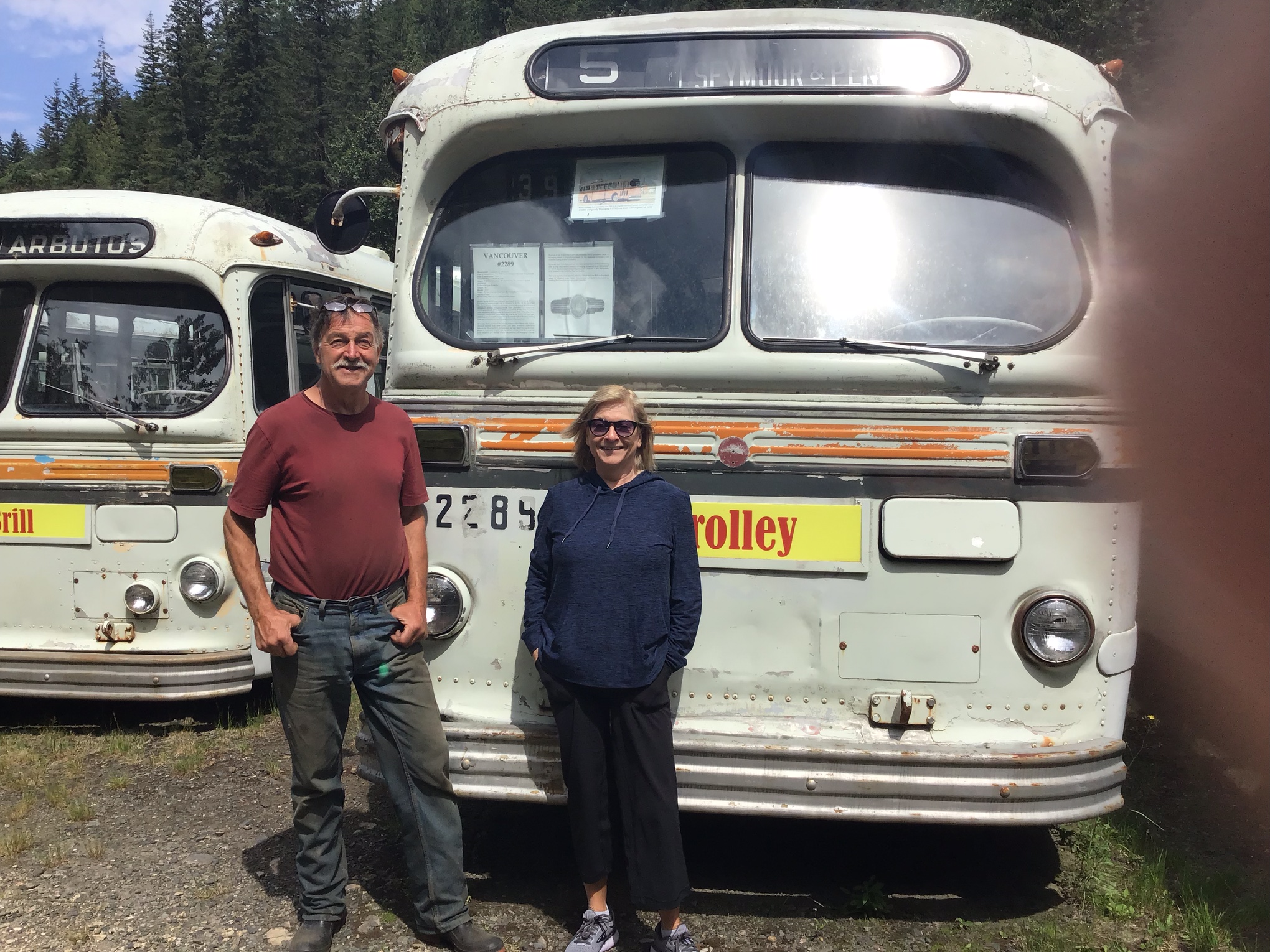
Hal Wright, Eve Lazarus and Brill 2289. Hal rescued the Brills from a scrapyard in 2001 and brought them to Sandon for restoration. The Brills operated in Vancouver until 1984 when they were retired prior to Expo. July 2022
During his 40-year career as a Vancouver bus driver, my friend Angus McIntyre drove many of these buses – including 2289 shown here and in the previous photo. Angus McIntyre photo, taken at the end of the Nanaimo route at Slocan and Kingsway in 1983
Japanese Internment:

Over the years, Sandon has been besieged by avalanches, floods and fires. In 1900, a fire destroyed most of the business section of the town. Silver prices tanked and mines folded after WW1. Then when things looked bleakest and population declined to around 100 in 1942, Sandon became an internment camp for close to 1,000 Japanese/Canadians. They fixed up abandoned buildings and revived the town. After they left in 1945 the population dropped to 30. Ten years later a flood finished off the lower part of Sandon. Today the population is five.

Sandon powerhouse
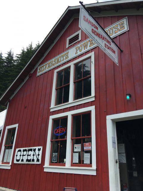
The 1916 Silversmith powerhouse provided electricity for the mine. It’s fully functioning and Hal sells power to BC Hydro. Eve Lazarus photo
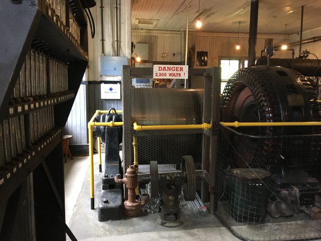
Sandon Silversmith powerhouse
Powered by a 1905 Westinghouse generator. Eve Lazarus photo

Sandon has a museum, a gift shop and a food truck also owned by Hal, which sees more than 60,000 visitors every year. We saw more tourists in Sandon then we did wandering around many other fully functioning small towns. And, a mine is once again operating in the area. Apparently galena (made up of 20% silver, 60% lead and 20% zinc) is making a come back, and so it seems is Sandon.

Arrow Lake ferry
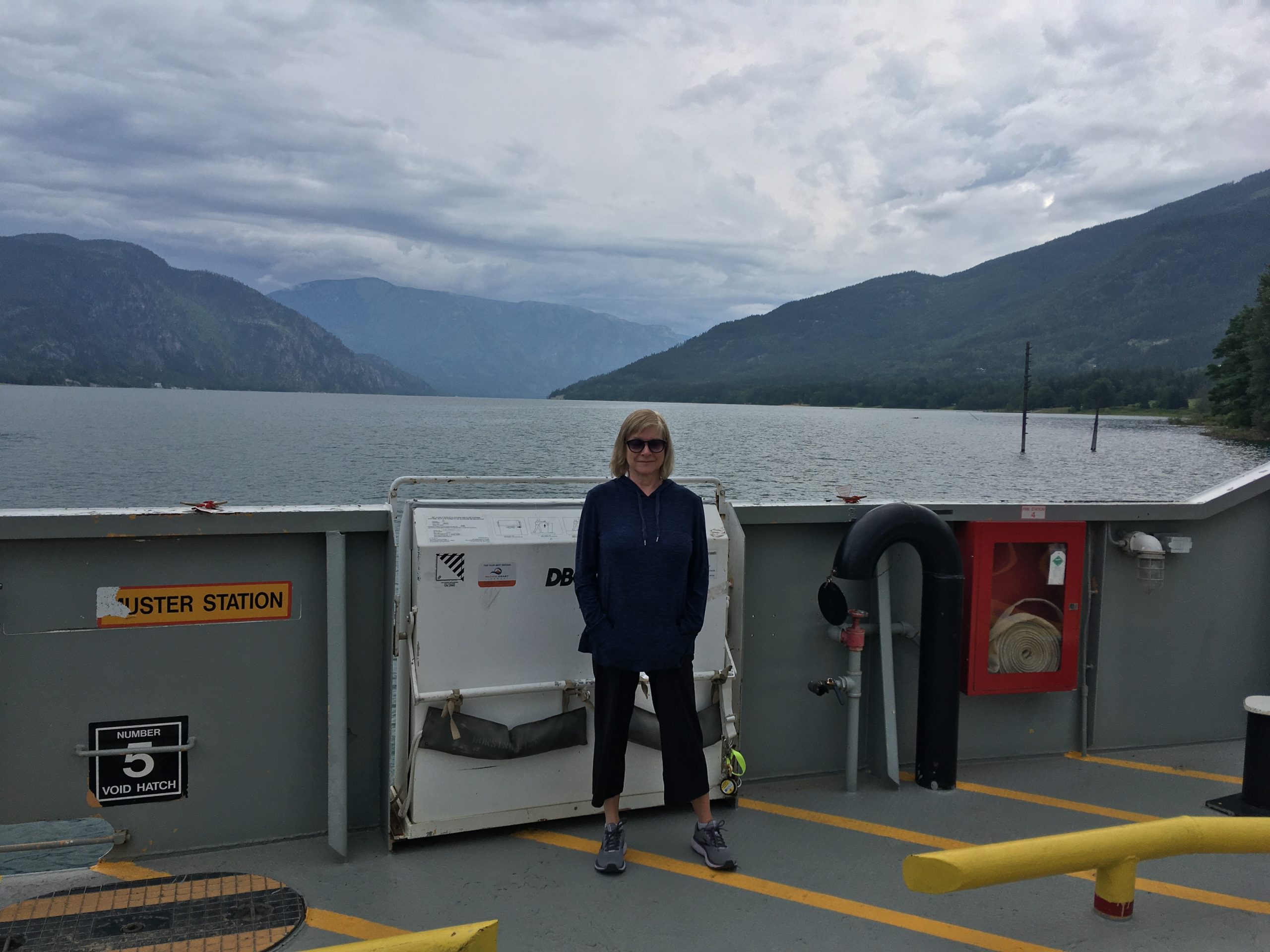
Our travels that day took us from Vernon, across Arrow Lake by a delightful free ferry, through little towns such as Nakusp and New Denver and included a detour to Sandon and onto Nelson via Kaslo – about 400 kms

© All rights reserved. Unless otherwise indicated, all blog content copyright Eve Lazarus.


The Dupont Street Train Station and the Marco Polo Restaurant

the_title()

Long before the Vancouver Film School occupied the building at East Pender and Columbia Streets, there was a railway station that was later repurposed into the legendary Marco Polo restaurant. 

Story from Vancouver Exposed: Searching for the City’s Hidden History

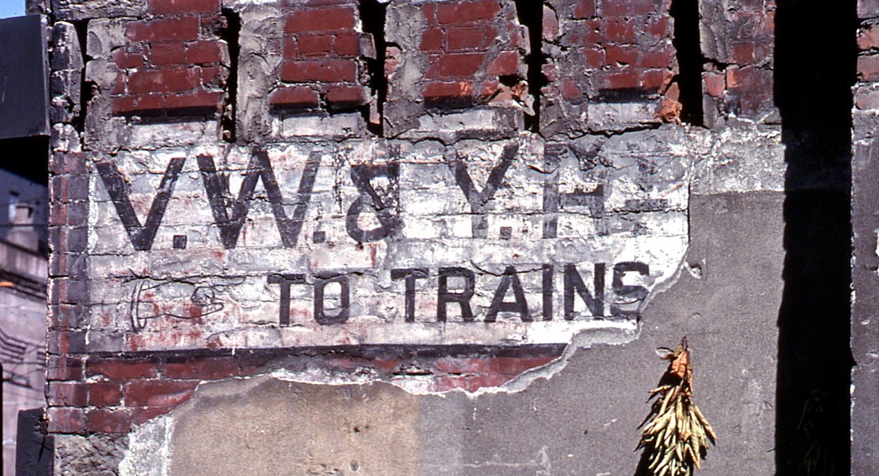
Sign from the Vancouver, Westminster and Yukon Railway depot, 1979
The sign stayed on the building until it was demolished in 1983. Angus McIntyre photo, 1979
Train Station:

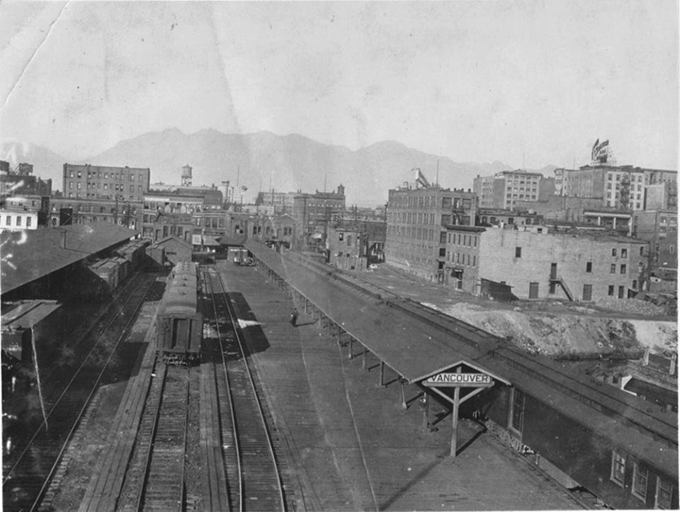
If you’re walking around Chinatown, you’ll likely notice the four-storey brick building at the corner of East Pender and Columbia Streets, now home to the Vancouver Film School. But if you were to take a stroll down the 100 block of East Pender in the early years of the 20th Century, you would actually be on busy Dupont Street and you’d find visitors from the U.S. disembarking at the Vancouver, Westminster and Yukon Rail depot.

The VW&YR depot on Dupont street in 1915
VWYR depot on Dupont Street (now east Pender Street) in 1915. Vancouver Archives

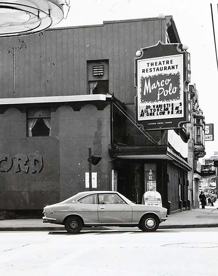
Several hundred people came to see the first fast train leave for Seattle on March 20, 1905 and cross the new trestle bridge that connected the north and south sides of False Creek. The last train left on May 31, 1917 and the building turned into the Hu Ye Restaurant and later the Forbidden City. The last and most famous tenant was the Marco Polo Restaurant.

The VW&YR depot on Dupont street in 1915
The VW&YR depot on Dupont Street (now East Pender) ca.1915. Tom Carter collection
The Ghost Sign:

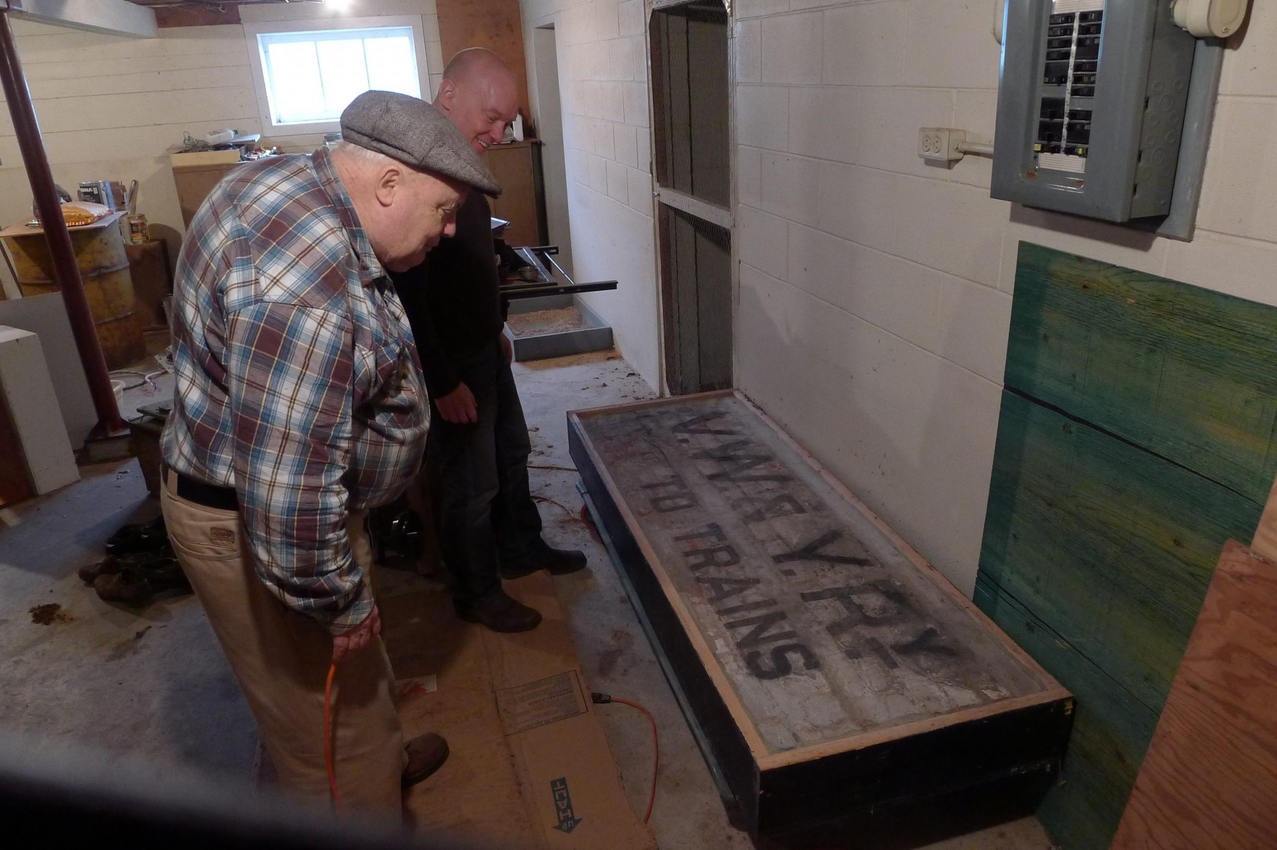
Before the building could be destroyed in 1983, heritage advocate Arthur Irving made a deal with the demolition crew and pried 88 bricks off the wall that still had the original railway sign VW&Y To Trains printed in black letters. He had the bricks mounted in a box to preserve them, and in doing so, saved one of the few pieces that remain of the Vancouver Westminster and Yukon Railway that operated between 1904 and 1908.

Tom Carter and Arthur Irving with the vintage railway sign in 2012. Andrew Martin photo

After Arthur died in 2018, Tom was helping to clear out his house when he came across the sign and the blueprints for the Great Northern Station built in 1919. “We found them in Arthur’s basement, in a bathtub salvaged from the 1916 Hotel Vancouver,” says Tom.

Marco Polo restaurant, 90 East Pender Street, Vancouver
The Marco Polo occupied 90 East Pender Street for decades before moving to North Van in 1982. Tom Carter collection

The brick sign and the blueprints are with the West Coast Railway Association in Squamish. The bathtub is in Arthur’s next-door neighbour’s garden.

Goad's map
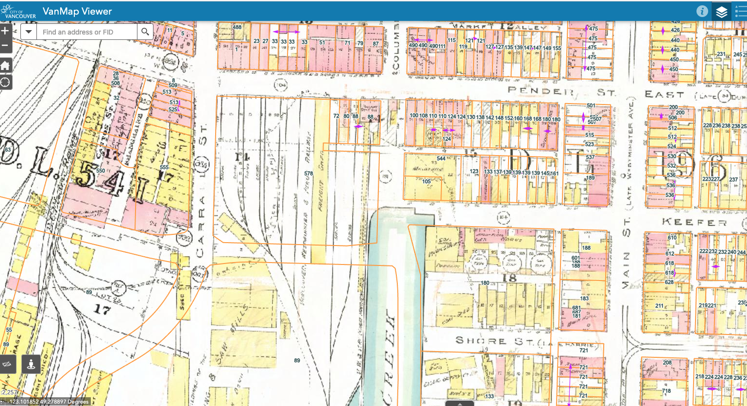
Goad’s Map of 1912 showing the train depot. With thanks to Tom Carter

© Eve Lazarus, 2022

Related:

The Fake House and the Thornton Tunnel

the_title()

There is a fake house in Burnaby that has fooled even some of its closest neighbours since 1967. Rumours have spread that it’s everything from a government safe house to an animal crematorium, but the truth is far more interesting.

From Vancouver Exposed: Searching for the City’s Hidden History

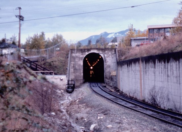
South portal of the Thornton Tunnel. Angus McIntyre photo, 1975
The Fake House:

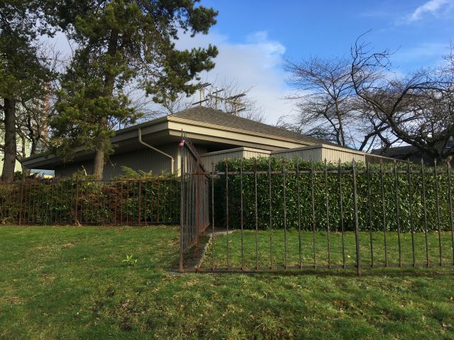
The house is actually a huge ventilation shaft that’s hidden in plain sight. It is set in a nicely landscaped garden, and sits about 45 metres above the CN tracks at the midpoint of the Thornton Tunnel. Instead of a kitchen and dining room, ventilation machines and very big fans operating inside. The tip-off is the metal “keep out” wrought-iron fence, the absence of windows and the concrete barriers where a front porch would typically be.

CN’s fake Burnaby house at the corner of Frances Street and Ingleton Avenue.  Eve Lazarus photo, 2020
The Tunnel:

The Thornton Tunnel took CN two years to build. It opened in 1968. The tunnel is 3.4 kilometres long and runs from the south end of the Ironworkers Memorial Bridge, under Burnaby and comes out at Dawson Street behind some warehouses.

Larry Lundgren was a switchman for CN from 1967 to 1972 and frequently found himself stuck at the wrong end of the train after a 10 to 15 minute ride through the tunnel. “As sure as heck a ship would come along and the bridge span would be lifted and you’d be sitting in the caboose just gasping,” said Larry.

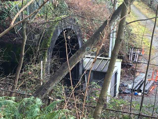
Entrance to Thornton Tunnel, built in 1968. Eve Lazarus photo, 2020
The Bridge:

Then, as now, marine traffic has the right-of-way and the wait could be up to 40 minutes for a train wanting to cross Burrard Inlet. Larry says when he worked for the railway it wouldn’t be unusual to take an 80-car coal train through the tunnel with a crew of four—two in the front and two in the back. “It was pretty hazardous because the engine is spewing stuff and there is only so much the fan could take out of there,” he says.

Nowadays, there are two crew members per train and they sit in the front. It takes up to 20 minutes to clear the exhaust so that there’s enough air for the occupants of the next train. That limits use of the tunnel to about two trains an hour. People who live above the tunnel tell me that you can hear a “clickety-clack” or a “banging” sound and feel the vibrations when the trains go through.

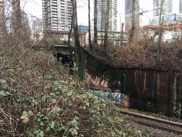
Southern portal of Thornton Tunnel, below Dawson Street. Eve Lazarus photo, 2020

© All rights reserved. Unless otherwise indicated, all blog content copyright Eve Lazarus.
We held a funeral for the Birks Building

the_title()

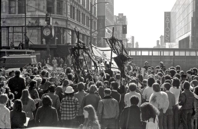
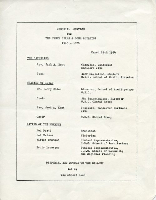
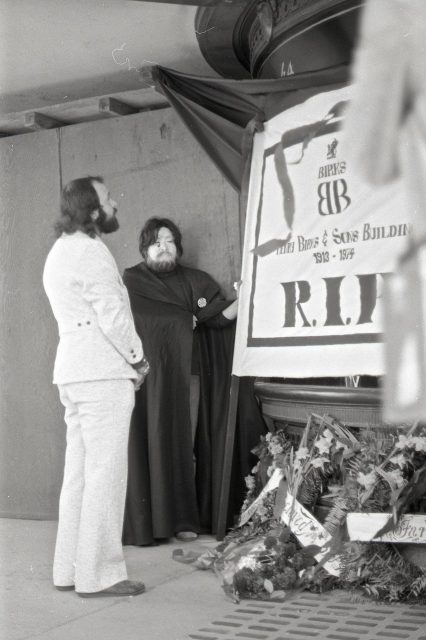
At 2:00 pm on Sunday March 24, 1974, a group of about a 100 people, many of them students and professors from the UBC School of Architecture, came together in a mock funeral for the Birks Building, an eleven storey Edwardian masterpiece at Georgia and Granville with a terracotta façade and a curved front corner.

Angus McIntyre climbed up on the bed of a dump truck to capture this photo of protestors outside the Birks Building in 1974

Story from Vancouver Exposed: Searching for the City’s Hidden History (also the cover photo). Photos by Angus McIntyre

Program for the memorial service, courtesy Angus McIntyre
And the band played:

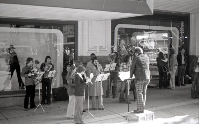
They marched from the old Vancouver Art Gallery at Georgia and Thurlow, led by a police escort and accompanied by a New Orleans funeral band playing a sombre dirge. The mourners assembled under the “meet me at the Birk’s clock,” an ornate iron timepiece that stood more than 20 feet tall and for decades had been a local landmark and familiar meeting place. For generations of Vancouverites, “Meet you at the Birks clock” was a common phrase.

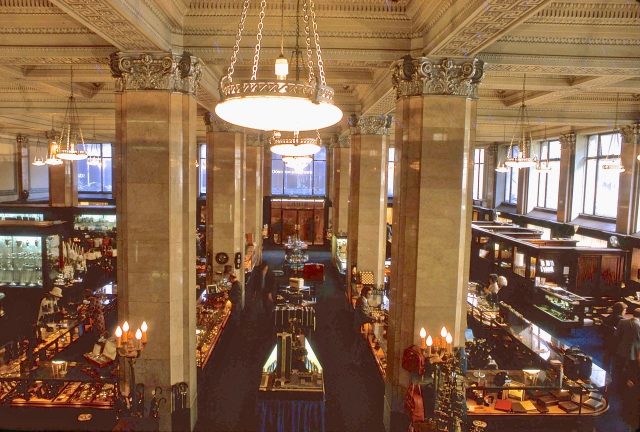
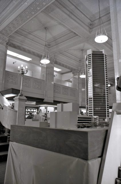
The stunning Interior of the Birks Building. Angus McIntyre photo, 1974
An act of architectural vanalism:

On this day, it was too late to stop the demolition—it had already begun—but not too late to protest what author and artist Michael Kluckner and others have called an egregious act of architectural vandalism.

The crew working on the new building across the road shut off the air compressors and laid down their tools. Reverend Jack Kent, chaplain of the Vancouver Mariners Club officiated. He was accompanied by a choir.

“North Van bus on West Georgia Street is visible through the window. Conductor is standing on two Canada Dry wood boxes. It was the era of checks and flared pants,” Angus McIntyre, 1974

Angus McIntyre then 26, grabbed his Konica Autoreflex T2 35mm camera and rode his bike downtown to record the event.

Ceremony:

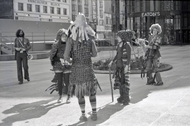
“There was a Gathering, a Sharing of Ideas, a Choir performance and a Laying of the Wreaths,” Angus told me. “A small group of people wearing recycled videotape clothing put hexes on new buildings nearby. As soon as it came time to return to the Art Gallery, the band switched to Dixieland jazz, and the mood became slightly more upbeat.”

Some protestors wore Video Armour crocheted out of used videotapes by Evelyn Roth. Angus McIntyre photo, 1974

And just like that, the beautiful old Birks Building—well not that old really—only 61 in 1974—was killed off to make way for the Scotia Tower and Vancouver Centre mall.

For a long time after the funeral, this R.I.P. banner hung in a second storey office window at the Sam Kee building on Pender Street. Angus McIntyre photo, 1974

The only positive thing to come out of the loss of this much-loved building was that it mobilized the heritage preservation community in Vancouver and saved many of our other fine old buildings such as the Orpheum Theatre, Hudson’s Bay, Waterfront Station, the Hotel Vancouver and the Marine Building—from a similar fate.

Inside Birks Building and the model of the Scotia Tower that will replace it. Angus McIntyre photo, 1974
Related:

© All rights reserved. Unless otherwise indicated, content copyright Eve Lazarus.
Meet Vancouver’s Newest Street Photographers

the_title()

When I think of street photographers, the first names that usually spring to mind are Fred Herzog, Foncie Pullice, Greg Girard, Michael de Courcy, Curt Lang and Bruce Stewart. But there were so many other great photographers shooting Vancouver in the 1950s to 1980s—names like Paul Wong, Tony Westman, Angus McIntyre and Svend-Erik Eriksen (Where were the women?)

These days everybody has a cell phone, and while you might think that makes street photographers irrelevant, there’s a group called Vancouver Street Photography Collective that are doing some really interesting things.
By Vianditya Dewanata

I’d been following some of their work on Instagram and went to their first exhibition last September.
Trevor Wide, Chris McCann and Stuart Weir are the co-founders behind a Facebook and Instagram page that features the Collective’s works. In his day job, Trevor is a visual effects artist for the movies, and photography he says, is a nice way to get outside his room and work outside the lines.

By Trevor Wide

Street photographers hashtag vanspc in their post and the best photos of the week are highlighted on the Instagram account. “We started getting more followers and we noticed that people were connecting with each other on Instagram chat and giving critique and something was happening,” he says. “The Exhibition was our catalyst to get us out there and get known and bring together a whole world of street photographers from Vancouver and beyond.”

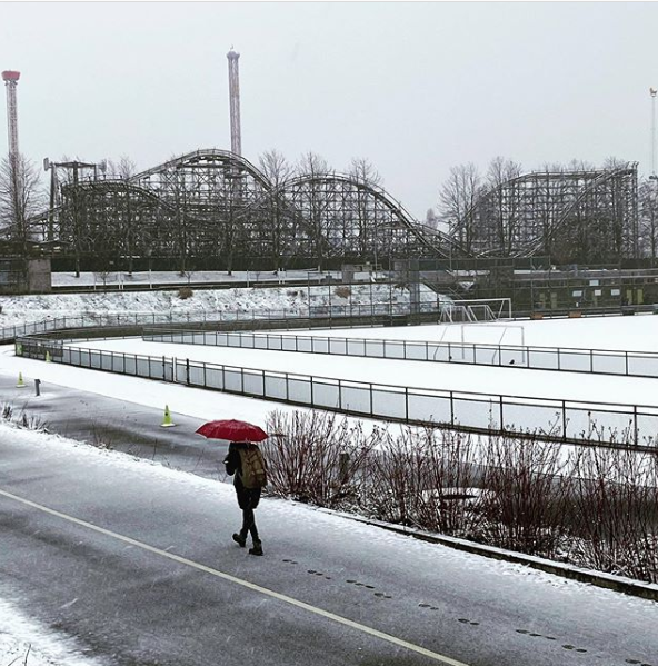
Rollercoaster at the PNE. Kathryn Ford photo

The members are a multi-cultural group that range from a 14-year-old to people in their 70s and they are all in different stages of their photography.

“We’ve got junior amateur photographers to professional photographers, everybody is helping each other out,” says Trevor. “We’re just good friends, sharing our art and our love for Vancouver.”

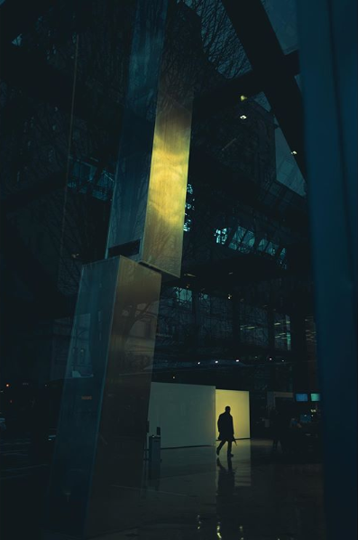
Circling the Bay on Granville and Georgia. Craig Sheppard photo

So, what is a street photographer in 2020?

“There are a lot of different interpretations, but in general it’s being able to capture a decisive moment—capturing humanity or what humanity has touched or left behind. It could be anything from architecture to people in public spaces to candid street portraits,” says Trevor. “Camera gear doesn’t matter—you could have an iPhone. You’ve got no lights, no tripod, you are just using the world around you to get your shot and there’s something exhilarating about going out there and not knowing what you are going to take and just trying to capture that moment or that mood.”

Leica M6 | 28mm | Hp5. Jody Hill Photo

To step it up to the next level, Trevor says the Collective plans to publish a magazine this year. “There are a lot of people interested. It’s a good way to get people to physically look and touch our work because it’s a lot different when you see a print rather than a photo through the small screen on your phone.”

© All rights reserved. Unless otherwise indicated, all blog content copyright Eve Lazarus.