Every Place Has a Story

The Evolution of Devonian Harbour Park

the_title()

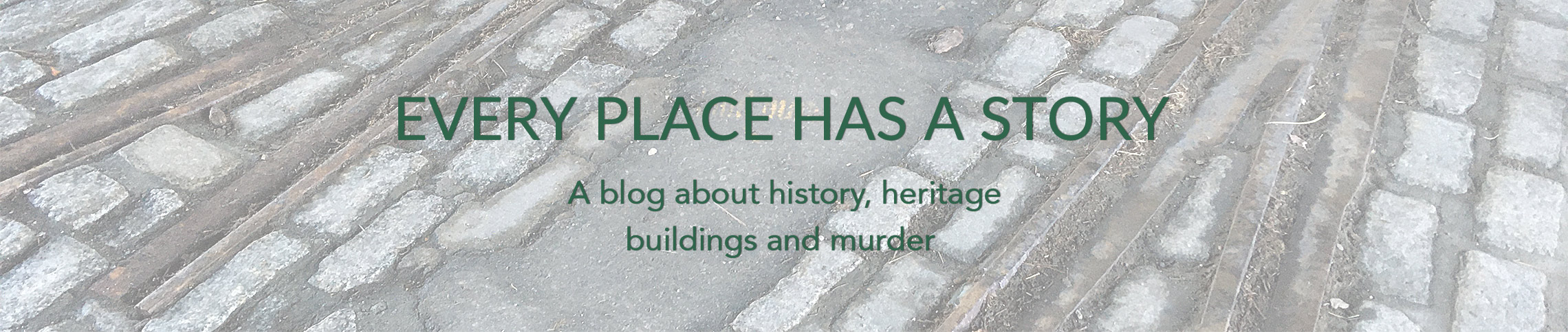
The name of the 11-acre green space at the entrance to Stanley Park known as Devonian Harbour Park has nothing to do with its indigenous history, the land’s connection to the Kanakas, the buildings that once dotted its landscape or Vancouver. The park was named after the Calgary-based Devonian Group of Charitable Foundations which forked over $600,000 to develop the site to its present look in 1983.

From Vancouver Exposed: Searching for the City’s Hidden History

Note the lovely old Stuart Building (1909-1982) Bruce Stewart photos
Kanaka:

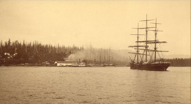
Kanaka was a term for indigenous Hawaiians who came to Canada in the early 1800s to work for the Hudson’s Bay Company’s fur trade. Most went home, but some stayed, married Squamish women and settled in Coal Harbour.

By the early 1900s, the Kanakas had been chased out and moved to the Mission Reserve in North Vancouver. That left the land free to develop. And, in 1911, Vancouver’s population of nearly 150,000 felt big enough to sustain a 10,000-seat arena. It was built by a couple of young guys from Victoria: brothers Frank and Lester Patrick (aged 25 and 27 respectively) who needed a home for their new Pacific Coast Hockey Association. As a comparison, Rogers Arena, built in 1995, has a capacity of 18,910.

Denman Arena fire, August 1936. Courtesy Canadian Colour and Vancouver Archives.
Denman Arena:

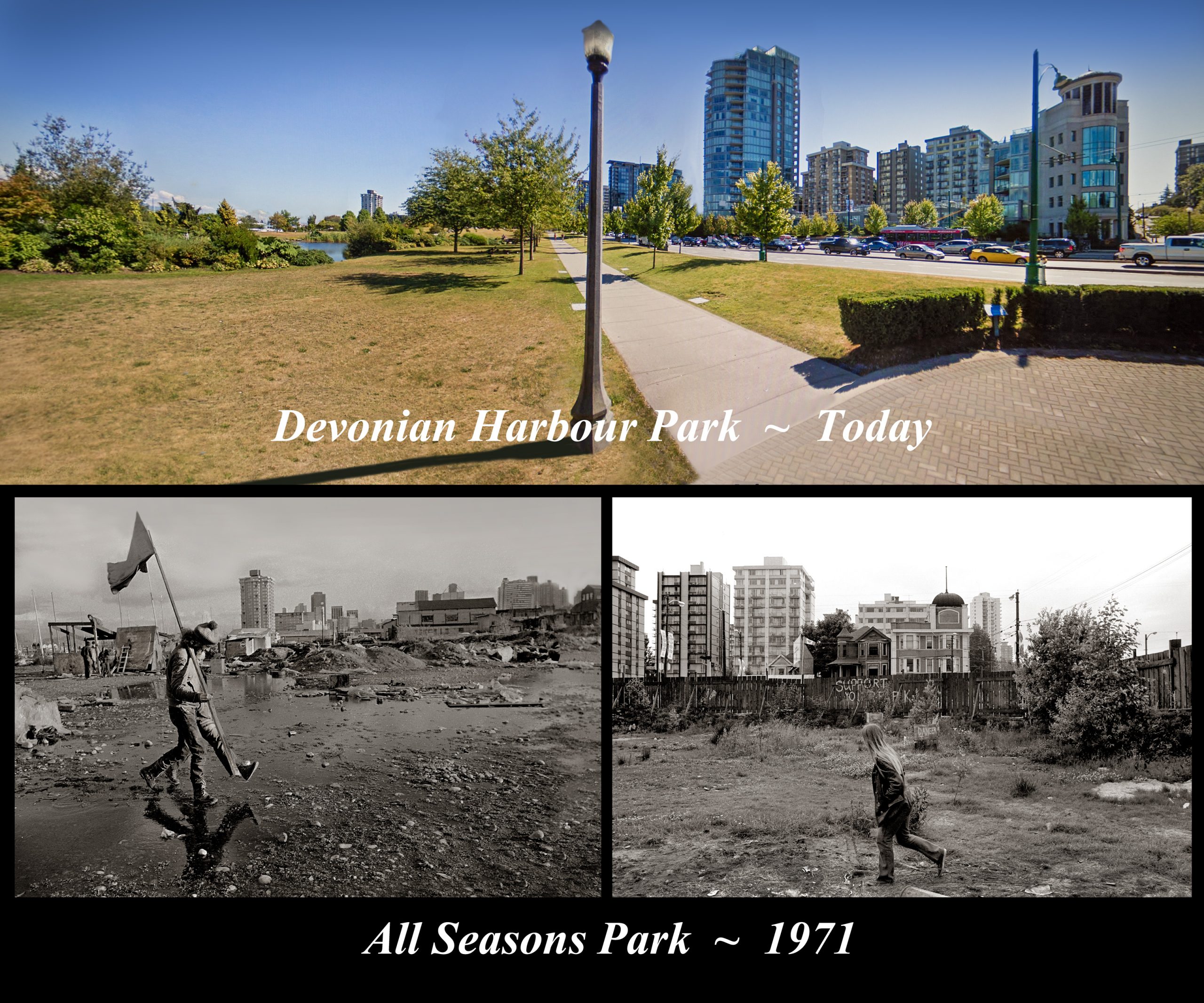
In 1915, the Denman Arena hosted Vancouver’s first and only Stanley Cup—when they beat the Ottawa Senators in three straight games. Rudolph Valentino judged a beauty contest, Arthur Conan Doyle (creator of Sherlock Holmes) gave a speech, and the arena was used for public skating, wrestling, military assemblies and musical performances.

Selwyn Pullan photographed the first proposed model in 1963

Then on August 20, 1936, just hours after 4,000 boxing fans watched Max Baer fight James Walsh, the building burned to the ground.

In 1927, the Patricks built the Denman Auditorium just to the south of the Denman Arena. The Auditorium survived the fire, went through a few different owners and names, hosted everything from political rallies to a strange assortment of revivalists and faith healers from the States.

Bruce Stewart took these photos of the ‘tribe’ in residence in November 1971. He had met with Rod Marining, later co-founder of Greenpeace and Rod was able to rally the tribe for this amazing ensemble shot of everyone on the big rock. “Later in the week, I ventured down to the small a-frame lean-to during a snowstorm to meet up with the gang and to present my photographs,” says Bruce.
Development:

The building was demolished in 1959 to make way for the opening of the Queen Elizabeth Theatre.

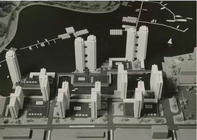
Now devoid of buildings, developers dreamed of hotels and condos. The first attempt came from New York in the early 1960s. The second, by a local outfit called Harbour Park Developments that proposed 15 towers soaring up to 31-storeys in height. The third was a plan by the Four Seasons Hotel chain. They wanted to build a 14-storey hotel, three 30-storey condos towers, and a bunch of townhouses.

A peace sign garden at All Seasons Park, the proposed site of a Four Seasons Hotel near the entrance to Stanley Park, on May 30, 1971.  Gordon Sedawie photo, Province
Hippies:

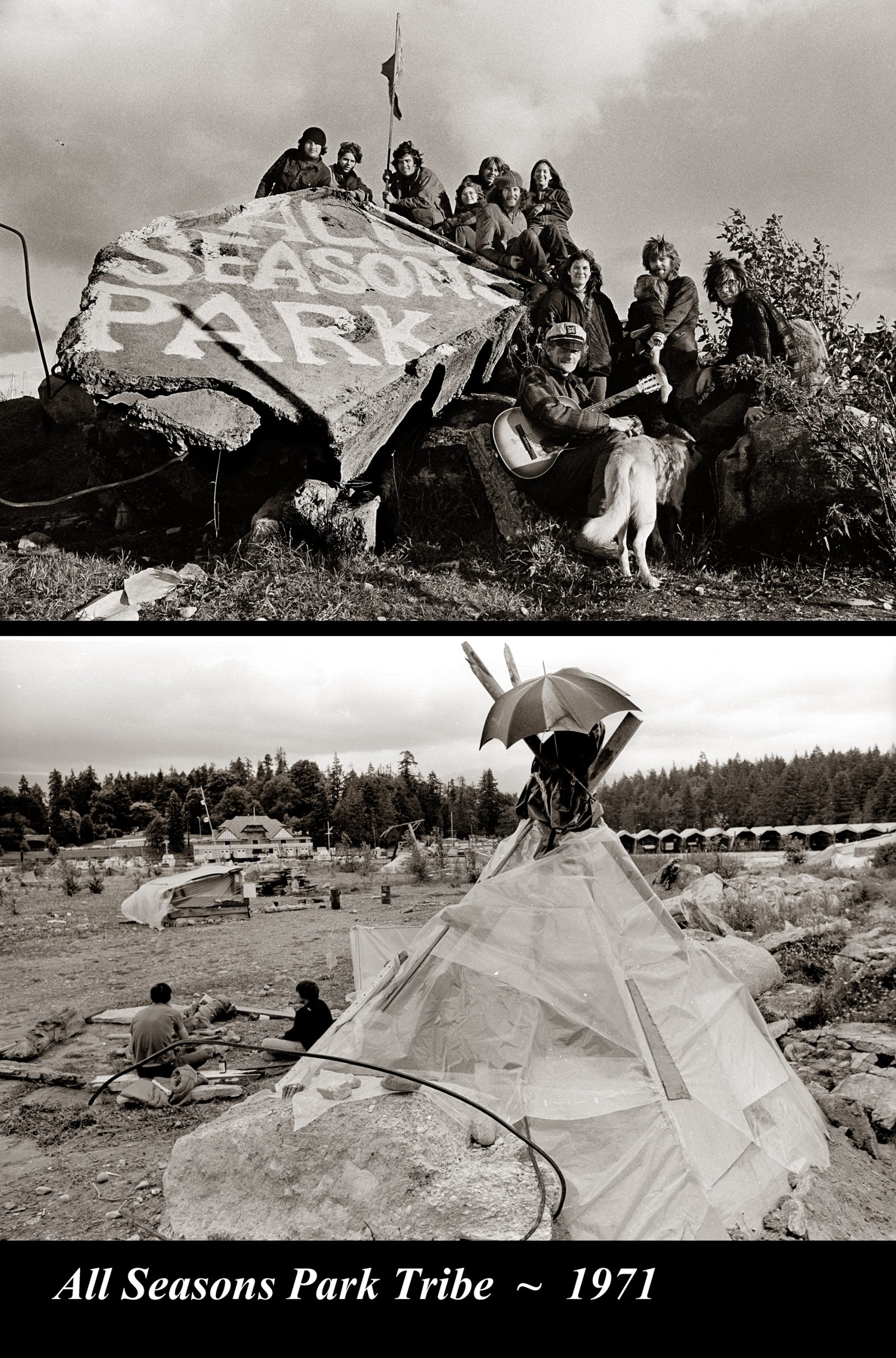
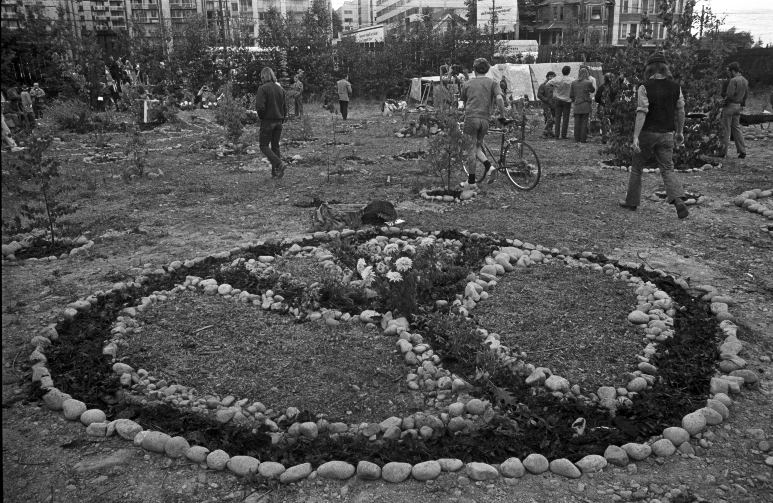
On May 29, 1971 about a hundred hippie/activists took over the site. They planted maple trees and vegetables, dug a pond, and installed children’s playground equipment. They called it All Seasons Park. The hippies lasted just under a year. Mayor Tom Campbell brought in the backhoes and knocked all the shelters down. Campbell’s own development dream fell apart later that year when the Federal government refused to hand over a crucial piece of land. Instead, the land was annexed to Stanley Park and purchased by the City of Vancouver.

One of the most popular features of the park is the bronze sculpture of the woman sitting on the park bench. She’s searching through her bag looking for the glasses that she’s forgotten are on top of her head. One Valentine’s Day, the woman was joined by another bronze statue—that of North Vancouver pioneer Walter Draycott. No one is saying how Walter got all the way to Stanley Park from his Lynn Valley bench, but he was returned without incident and bolted into place to stop him from wandering off again. Eve Lazarus photo, 2020

© All rights reserved. Unless otherwise indicated, all blog content copyright Eve Lazarus

The North Shore’s Spirit Trail – Moodyville (part 1)

the_title()


In May 2014, the City of North Vancouver inked a deal with the Squamish Nation and moved a step closer to realizing the dream of building a 35-kilometre waterfront trail that would wind its way from Deep Cove to Horseshoe Bay.  The mostly finished portion of the Spirit Trail runs from Sunrise Park (just above Park and Tilford Gardens) to 18th Street in West Vancouver–(just past John Lawson Park). The ride (or walk) along the finished portion is about 20 km return.

The Moodyville Park section was completed in 2015. The trail includes an impressive overpass to Heywood Street, a mini-suspension bridge, public art, and some now fading public markers. You’ll have to reach deep down into your imagination, because the only thing left of Moodyville is a small park with some signage surrounded by a lot of building activity.

A two-storey hotel opened in 1883 and it was reportedly “a comfortable and exceedingly well-managed” operation, with a bar stocked with top wines and liquors, and where “drunkenness was unknown.” The Columbian, photo NVMA 1900

Up you go over the new overpass, and a great view of the working waterfront that takes you right into Moodyville, once a thriving town built entirely around lumber. Settled in the early 1860s, the town was completely distinct from the rest of North Vancouver with a business district that included a library, Masonic lodge, school, jail and cookhouse situated where the railway tracks and grain elevators are today. The mill was at the foot of what is now Moody Avenue, and a wooden wharf extended from the mill out over deep water. The town even had its own ferry service.

William Nahanee (with laundry bag) and a group of longshoremen on the dock of Moodyville Sawmill in 1889. CVA Mi P2

While the workers were comprised of several different races who could trace their origins back to Europe, Asia, the Pacific Islands “Kanakas,” Latin America and the West Indies, lived in segregated housing; the wealthy lived in “Nob Hill” a nod to San Francisco’s prestigious neighbourhood.

The most prestigious house was Invermere, known as the “Big House” and built in the late 1870s for Hugh Nelson a partner in the Moodyville Sawmill Company (later Lieutenant Governor of BC). Lumberman John Hendry bought Invermere and lived there for a time. His son-in-law Eric Hamber, another Lieutenant Governor of BC, demolished the house after his death. The replacement house is at 543 East 1st Street.

The Big House in 1881. Courtesy NVMA

Electricity came to Moodyville in 1882, a full five years before Vancouver and the electric lights reflected all the way across the waters to Hastings Mill in Vancouver.  Moodyville was the first town site north of San Francisco to sport electric street lights.

By 1898 the Mill’s fortunes had peaked and in 1901 it closed.  People moved away in search of work, and business activity shifted to the waterfront at the foot of Lonsdale Avenue. Moodyville officially became part of North Vancouver in 1925.

“Moodyville was the largest, oldest, most prosperous and certainly most decorous settlement on the Inlet. It had a population of several hundred, all respectable families, with tidy homes strung along well-laid out streets up the hillside from  Moody’s mill.” Photo ca.1890 CVA Mi P22

The Low Level Road, constructed two years later, paralleled the railway line.  Much of the hillside was scraped away and re-deposited as fill on the tidal flats to reclaim 15 acres (6 hectares). Midland Pacific was first to locate on the fill and opened a grain elevator in 1928. The area known as Nob Hill was subdivided, war-time housing followed, and a housing development called Ridgeway Place sold in the late 1950s.

With thanks to the North Vancouver Museum and Archives for letting me work on their  Water’s Edge Exhibit in 2016.

Moodyville to Lonsdale Quay (part 2) 

Lonsdale Quay (part 3)

Mosquito Creek (part 4)

Harbourside (part 5) 

Pemberton to Capilano River  (part 6) 

West Vancouver (part 7)

© All rights reserved. Unless otherwise indicated, all blog content copyright Eve Lazarus.