Every Place Has a Story

The North Shore’s Spirit Trail – Lonsdale Quay (part 3)

the_title()

There’s so much history at Lonsdale Quay, that I thought we’d stay here and let it roll over us while we caffeinate at the Bean around the World (now the Shipyards)

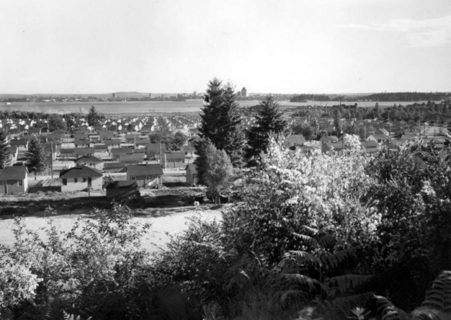
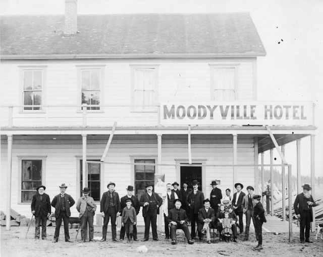
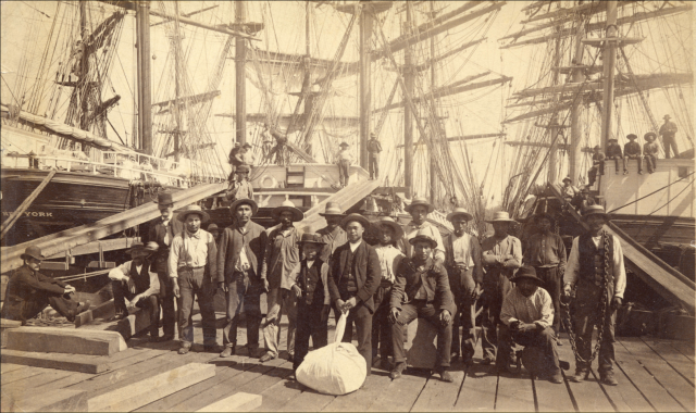
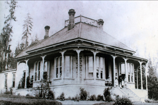
If we time travelled back to the late 1880s, we’d be sitting on Tom Turner “ranch.” It stretched from Chesterfield to Rogers Avenue and sloped down from Esplanade to the water. The farm house sat roughly in the middle—where ICBC is today. Turner’s farm supplied vegetables to Moodyville residents, and because he had the only grass field in North Vancouver, his farm became a picnic destination for the locals. Turner later sold the property to J.C. Keith (namesake of Keith Road) and returned to England.

North Vancouver Hotel ca.1905. CVA OUT P575.1

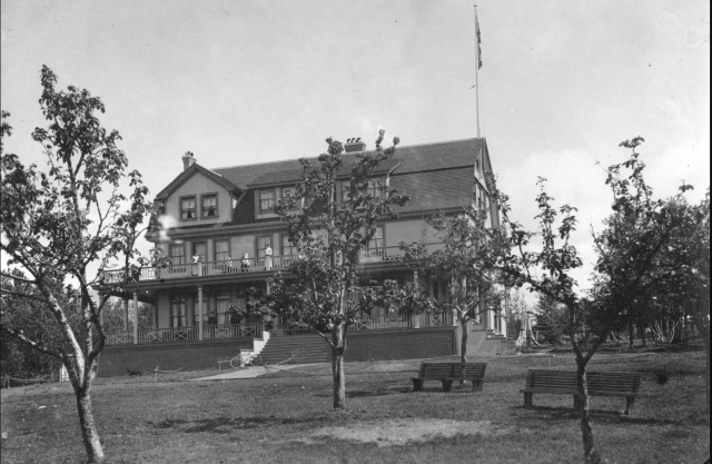
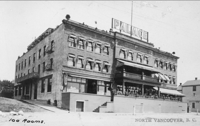
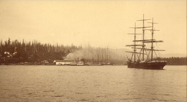
In those days, Esplanade was a wide tree-lined promenade that extended west along the shoreline from Lonsdale to just past Chesterfield. The Hotel North Vancouver and its Pavilion were on the north side of the street, where the Shoppers Drug Mart is today. The hotel, owned by Pete Larson, attracted people from all over Vancouver who took the ferry and stayed for $2 a day or $10 a week, or just came for the day to check out the bandstand, balloon flights or perhaps tight-rope walking. The hotel’s grounds also had a boat dock and a swimming beach, because in those days the water reached to just below Esplanade.

North Vancouver train tunnel opening in 1928. Courtesy NVMA

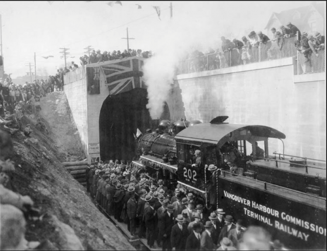
Unless you’ve been stuck at the foot of Chesterfield Avenue waiting for a train to pass, you’ve probably not given much thought to “the Lonsdale Subway.” The Subway is actually a 1,585 foot tunnel, built in the late 1920s to link two railways. The tunnel ran from St. Georges to Chesterfield and connected the Terminal Railway to the Pacific Great Eastern Railway (later BC Rail, then CN Rail).

At the foot of Lonsdale in the 1970s. NVMA 15806

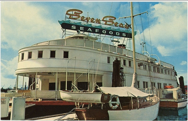
Most North Vancouver residents will remember the Seven Seas, a restaurant that was moored at the foot of Lonsdale. Some of you may even remember it as Norvan Ferry #5, a forerunner to the Seabus, and one of the ferries that brought people to Vancouver and back. Ferry #5 went into service in 1941 and was sold to restauranteur Harry Almas for $12,000 in 1959, a year after the ferries took their last run across the Inlet.

The Seabus in 1977. Courtesy NVMA

After the Seabus launched in 1977 and kick-started economic activity in Lower Lonsdale, a plan was hatched for the Lonsdale Quay development. The thought was that densification of the area, with over 300 housing units, restaurants and shops would be encouraged, but care would also be taken to restore the heritage buildings in the corridor. Mayor Jack Loucks was certainly optimistic. “It has been said that Lonsdale Quay will become an extension of Granville Street,” he said. “I like to think that when the project is complete, Granville Street will become an extension of Lonsdale Avenue.”

Eve Lazarus photo

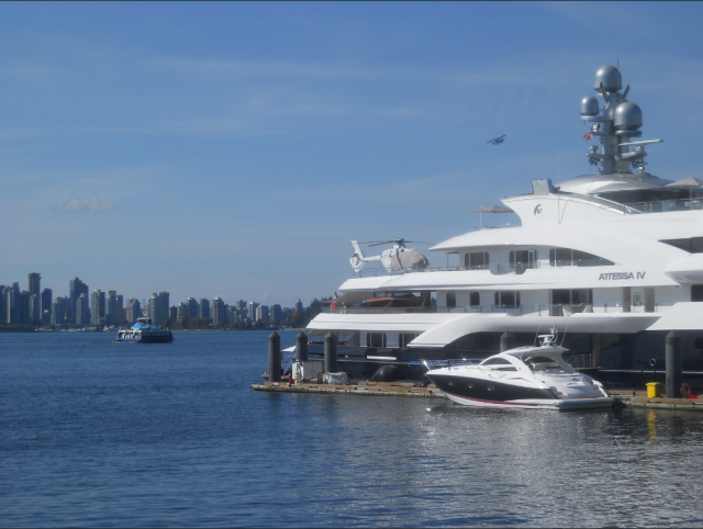
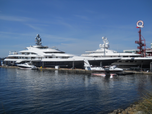
Well, perhaps not. More like a parking lot for billionaires and their luxury yachts.

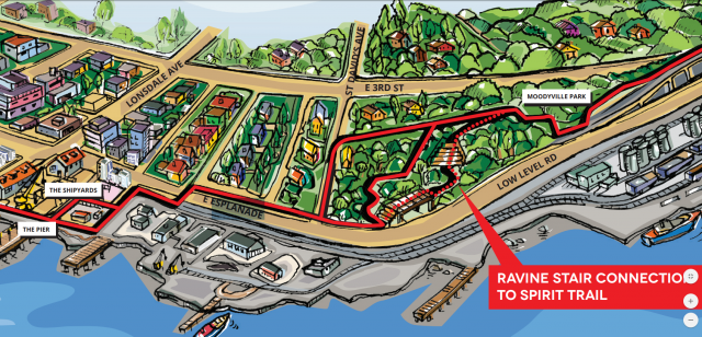
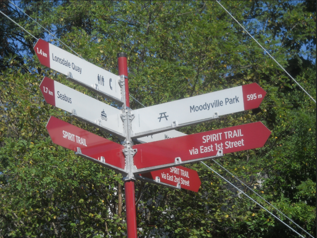
Next week we’re getting back on our bikes and cycling the newest part of the Spirit Trail from Lonsdale Quay to Mosquito Creek.

*Top photo: View of North Vancouver west of Lonsdale Avenue showing Tom Turner’s cabin in 1890. Courtesy CVA OUT P79

The North Shore’s Spirit Trail – Moodyville (part 1)

Moodyville to Lonsdale Quay (part 2) 

Mosquito Creek (part 4)

Harbourside (part 5) 

Pemberton to Capilano River  (part 6) 

West Vancouver (part 7)

The  © All rights reserved. Unless otherwise indicated, all blog content copyright Eve Lazarus.


Along the North Shore’s Spirit Trail – Moodyville to Lonsdale Quay (part 2)

the_title()

At the end of last week’s blog, I left you at Moodyville Park, the only thing left of a once thriving town. Now hop back on your bike and follow the signs west along First Street East—and be careful of those construction trucks! I imagine in another year or so this area will be unrecognizable, but occasionally you’ll see a bungalow–the lone standout in a sea of rubble.

North Vancouver war-time housing 1943. Courtesy BC Archives 41451

Some of those holdouts were built during WW2 when Wartime Housing, a crown corporation, built tracts of neat cottages for shipyard workers. According to North Vancouver Museum and Archives, rents averaged $20 per month plus $1.35 for water services. The website says about 100 wartime houses still survive, but I’m not confident how current that is.

You’ll see signs taking you down the squiggly path and onto Alder Street and along the working waterfront.

PGE moved to its temporary home on the Spirit Trail in 2014

The old Pacific Great Eastern (PGE) Railway-North Van’s first train station—is boarded up and stuck behind a chain link fence until a new home is found for it (I hope).

On January 1, 1914, the PGE began service from this station at the foot of Lonsdale Avenue to Dundarave. At the time the plan was to extend the tracks to Squamish, but that didn’t eventuate and the railway only went as far as Horseshoe Bay. The railway service ended in 1928, and the station became a bus depot, and then was used as offices until it was moved to Mahon Park in 1971. It was spiffied up and returned to its home at the foot of Lonsdale in 1971, and moved to its current location in 2014.

Palace Hotel in 1909. Courtesy NVMA 8155

The Spirit Trail takes you along Esplanade and down St. George’s to Victory Ship Way. If you look up the street you’ll see a 15-storey condo tower at East 2nd called the Olympic. In 1906 Lorenzo Reda built a brick hotel in that spot. Within two years, he added more rooms and a dance hall, and in 1908 the Palace Hotel boasted that it was “the only hotel in British Columbia with a roof garden.” Reda died in 1928. The hotel became the Olympic, and by the ‘70s (when it was known locally as the “Big O”), it was hosting rock bands and strippers. It was demolished in 1989.

The Shipyards in 1948, courtesy CVA Wat P58

.Aside from a couple of the old shipyard buildings and artifacts, most of the buildings have been torn down and replaced with condos. This was a hopping place during WWII, and Burrard Dry Docks was the first to hire women in significant numbers and pay them decent wages.

Women workers at Burrard Dry Docks, 1945. Courtesy NVMA 1421

And some of you may remember the Erection Shop that sat at the bottom of St. Georges until political correctness made the shipyards take the sign down for Expo 86.

We’ll start at Shipyards Coffee at Lonsdale Quay next week for a chat about the history of the area.

The North Shore’s Spirit Trail – Moodyville (part 1)

Lonsdale Quay (part 3)

Mosquito Creek (part 4)

Harbourside (part 5) 

Pemberton to Capilano River  (part 6) 

West Vancouver (part 7)

© All rights reserved. Unless otherwise indicated, all blog content copyright Eve Lazarus.

The North Shore’s Spirit Trail – Moodyville (part 1)

the_title()


In May 2014, the City of North Vancouver inked a deal with the Squamish Nation and moved a step closer to realizing the dream of building a 35-kilometre waterfront trail that would wind its way from Deep Cove to Horseshoe Bay.  The mostly finished portion of the Spirit Trail runs from Sunrise Park (just above Park and Tilford Gardens) to 18th Street in West Vancouver–(just past John Lawson Park). The ride (or walk) along the finished portion is about 20 km return.

The Moodyville Park section was completed in 2015. The trail includes an impressive overpass to Heywood Street, a mini-suspension bridge, public art, and some now fading public markers. You’ll have to reach deep down into your imagination, because the only thing left of Moodyville is a small park with some signage surrounded by a lot of building activity.

A two-storey hotel opened in 1883 and it was reportedly “a comfortable and exceedingly well-managed” operation, with a bar stocked with top wines and liquors, and where “drunkenness was unknown.” The Columbian, photo NVMA 1900

Up you go over the new overpass, and a great view of the working waterfront that takes you right into Moodyville, once a thriving town built entirely around lumber. Settled in the early 1860s, the town was completely distinct from the rest of North Vancouver with a business district that included a library, Masonic lodge, school, jail and cookhouse situated where the railway tracks and grain elevators are today. The mill was at the foot of what is now Moody Avenue, and a wooden wharf extended from the mill out over deep water. The town even had its own ferry service.

William Nahanee (with laundry bag) and a group of longshoremen on the dock of Moodyville Sawmill in 1889. CVA Mi P2

While the workers were comprised of several different races who could trace their origins back to Europe, Asia, the Pacific Islands “Kanakas,” Latin America and the West Indies, lived in segregated housing; the wealthy lived in “Nob Hill” a nod to San Francisco’s prestigious neighbourhood.

The most prestigious house was Invermere, known as the “Big House” and built in the late 1870s for Hugh Nelson a partner in the Moodyville Sawmill Company (later Lieutenant Governor of BC). Lumberman John Hendry bought Invermere and lived there for a time. His son-in-law Eric Hamber, another Lieutenant Governor of BC, demolished the house after his death. The replacement house is at 543 East 1st Street.

The Big House in 1881. Courtesy NVMA

Electricity came to Moodyville in 1882, a full five years before Vancouver and the electric lights reflected all the way across the waters to Hastings Mill in Vancouver.  Moodyville was the first town site north of San Francisco to sport electric street lights.

By 1898 the Mill’s fortunes had peaked and in 1901 it closed.  People moved away in search of work, and business activity shifted to the waterfront at the foot of Lonsdale Avenue. Moodyville officially became part of North Vancouver in 1925.

“Moodyville was the largest, oldest, most prosperous and certainly most decorous settlement on the Inlet. It had a population of several hundred, all respectable families, with tidy homes strung along well-laid out streets up the hillside from  Moody’s mill.” Photo ca.1890 CVA Mi P22

The Low Level Road, constructed two years later, paralleled the railway line.  Much of the hillside was scraped away and re-deposited as fill on the tidal flats to reclaim 15 acres (6 hectares). Midland Pacific was first to locate on the fill and opened a grain elevator in 1928. The area known as Nob Hill was subdivided, war-time housing followed, and a housing development called Ridgeway Place sold in the late 1950s.

With thanks to the North Vancouver Museum and Archives for letting me work on their  Water’s Edge Exhibit in 2016.

Moodyville to Lonsdale Quay (part 2) 

Lonsdale Quay (part 3)

Mosquito Creek (part 4)

Harbourside (part 5) 

Pemberton to Capilano River  (part 6) 

West Vancouver (part 7)

© All rights reserved. Unless otherwise indicated, all blog content copyright Eve Lazarus.